
chorusing, chanting nuthatches—drone of insects—single flute-like call note of ? perhaps a pigeon. early in the morning can definitely hear the freeway. not now.”
[Russell Towle's journal]
“August 27, 1985
[...]
Now I am at my cabin, [...] and enjoying this extremely clear, fall-like day. In fact—I have never seen it so clear in the summertime—the sky's deep blue, the wind makes the pines tremble and sparkle in the bright sunlight.
[...]
Lately I had occasion to meet Weyman Lundquist. He suggested that I keep on trying with Lovers Leap, and discussed some funding opportunities. I wrote a letter to Emory Gray, the owner of the 40 acres closest to the Leap—no reply yet. One week. If he is a willing seller, a great step could be taken for the protection of Lovers Leap, of which I remain convinced, as always since I first saw it 10 years ago, that it is one of the most beautiful places in the Sierra, and deserves the utmost protection from development, etc.
The Smart's Crossing case has reached a pleasant state of affairs; a preliminary injunction has been granted, allowing the public foot and road access to Smart's Crossing.”
[Russell Towle's journal]
“8/27/86 [...]
For something like the umpteenth time I was inspired to write by seeing the two young ground squirrels perched on the big oak. I awoke much less depressed yesterday and the Canyon Wren came around early and sang a lot, which it also did today.”
[Russell Towle's journal]
“8/27/87 [...]
A mouse snuck in and awoke me last night, about 4:00 AM. I managed to let it back out and returned to bed, where I slept late and woke up groggy, with some kind of inner ear problem—my balance was off—and am still groggy, still a little unbalanced.”
[Russell Towle's journal]
“8/27/01
Such a long time since I've written here! I am relying upon my e-mail, both incoming and outgoing messages, to provide a record of my life these days. Also, my webpages contain some information about this year's activities.
This summer Gay went to England to teach in the American School, so Greg & Janet & I had the place to ourselves. It was a good summer, with explorations of Wildcat Point, Wabena Trail, and Wabena Falls. Also a traverse of Giant Gap with Canyon O'Riley and Chris Schiller, and a visit to the upper canyon, Soda Springs, with Terra Nyssa.”
[Russell Towle's journal]
Green Valley Panorama
Looking south from Moody Ridge
Looking south from Moody Ridge
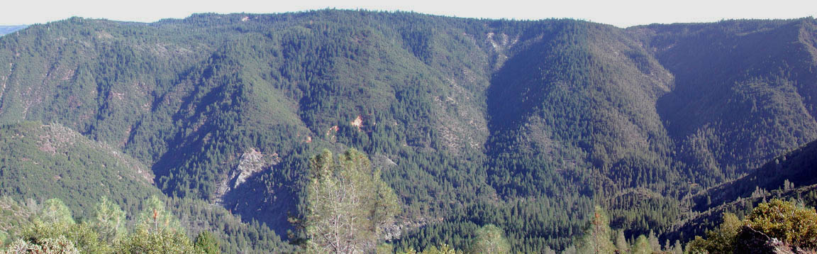 |
| August 27, 2001 Click to enlarge |
Crossing the Rubicon
[North Fork Trails blogpost, August 27, 2005I received an interesting letter from Tom Petersen over in Georgetown, which shows that, of course, the North Fork American area is not alone in having lost trails to logging and disuse. Tom has published a nice little book titled "Georgetown Hiking Trails (Trying to Get Lost Off the Divide)," and he writes, "My book is available in Auburn at Winston-Smith books, 933 Lincoln, 823-5940 and The Book Haven, address unknown, also Lincoln (formerly Seva's Books) . Or folks can call me at 530-333-4911 for direct mailings." In it you will find the old trails of the Rubicon River, and Otter Creek, and much much more.
http://northforktrails.blogspot.com/2005/08/crossing-rubicon.html ]
Here's Tom's letter:
Such is a very interesting letter.Hi Russell,
Thanks for the continued e-mails regarding the North Fork area. As a fellow trail nut, it's refreshing to know that I'm not alone in my own trail obsessions.
I especially enjoyed your e-mail about the USFS, (from timber protectors to timber pimps), right on! Having worked for the FS on the El Dorado National Forest I feel compelled to share some of my own insights.
I first became acquainted with the FS in May of 1987 while collecting rocks near Ellicott's bridge when a new ranger stopped and told me it was illegal to collect rocks without a permit. He threatened to cite me but said he wouldn't if I agreed to stop at the Georgetown Ranger station and obtain a permit. Fine. When I stopped in the office and inquired, the office staff broke out in laughter. Ranger Jack Palachi was new and trying to make a name for himself. (Jack is presently in charge of the OHV dept. for the entire state of Colorado.)
I met Jack a week later at a local softball game while our wives were playing on the same team. I complained to him about the lousy condition of our local trails and he was very interested, admitting that he didn't even know where many of the trails were. Jack hired me as a volunteer to do trail logs for $20 a day. Turns out that the Georgetown Ranger Station had lost track of some of their trails and hardly anyone working there even knew many of the trails. For some strange reason I've always loved old maps and finding old trails and at the time couldn't understand why the trails were in such bad shape.
The summers of 1988 and 1989 found me in charge of a YCC crew of 5 high school aged local delinquents working to resurrect every trail I could find in the district. I mistakenly thought that if the trails could be restored they would get used and we could keep the trail system going. How naive I was/am. To my ongoing dismay and frustration, most of those trails are as unused and forgotten as before. The few that have become active have been adopted by illegal OHV riders and I regret even clearing them now. Georgetown has a controversial 25,000 acre Rock Creek OHV park and many riders have grown tired of the regulations and seasonal closures there and shifted their riding into the Rubicon drainage where we worked to hard restoring abandoned trails.
Back in 1988 the USFS was adapting itself to the "Data General" computer that they had bought. The behemoth took up an entire 12X12 room. I spent an entire tortuous week stuck in the office entering trail data for the new system. After I was finished I proudly printed a document listing and describing every non-motorized trail in the district. I offered copies to anyone in the district via the office newspaper. I didn't get a single request.
The computer quickly changed an aspect of the USFS. Job promotions could be found anywhere in the U.S. using the postings on the D.G., so employees became more transitional than ever before. Rather than local folks working their way up through the local ranks, employees jumped from one district to another. Every summer there was a new batch of people working there.
The USFS is organized into different depts. In the 80's timber was king and recreation struggled for considerations. There was very poor communication between depts. I remember being appalled to discover that one of our trails had been used as a boundary line for a timber sale. Slash had obliterated it.
A resource officer overheard me complaining to Jack and offered to use "K-V" funds to restore the trail. I learned that the F.S. had a fund set aside to mitigate logging damage to trails. (In practice this fund usually went into the pockets of resource officers rather than be used as intended.) In this case the money was used to restore that particular trail.
The Georgetown district also suffers from the checkerboard of private lands. In 1989 the local district paid a trail contractor $65,000 to restore 16 miles of trail along the Rubicon River and around the east side of Hell Hole Reservoir. Beautiful job. The very next year Bohemia helicopter logged every other square section and obliterated half of the work. The same logging operation erased all of my YCC crew's work on the historic Steamboat trail on the north side of the reservoir. I left the district in disgust and went to work for the El Dorado Forest trail crew maintaining trails in Desolation Wilderness.
That trail crew also worked on trails in the Wrights Lake area where we witnessed the high grading of pristine old growth Red Fir under the guise of "salvage logging." Along most every trail outside the wilderness area. Shameful greed. I never worked for the Forest Circus again.
A couple of weeks ago my friend Rick and I spent a week in the Granite Chief Wilderness armed with a 1953 15min. topo. And determined to scout out as many old trails as possible in the area of the Five Lakes Basin, Diamond Crossing in particular. Back in 1987 I had been impressed with how nicely maintained the Tahoe NF trails in this area were. Not so anymore! Except for the main trail through the basin and the Powderhorn Creek trail, every other trail is in very bad shape. We found and followed with much difficulty every trail we sought; Meadow Lake, Little Powderhorn, Hell Hole, Steamboat, and Lagoon. We didn't see any other hikers the entire week, (although we spent most of our time on obscure trails); the last day we encountered two motorcycle riders trying to cross the entire wilderness, end to end, from Barker Pass to Hell Hole. They were stymied by the huge slide on the Hell Hole end of the trail.
Where have all the hikers gone? I don't know, but I have learned that most of the old trails have lost their need to exist, being superseded by roads. If more people used the trails the trails would maintain themselves. The trail system seems to be reducing itself to a very few main trails.
As an end note, the "small i" blazes that you refer to actually represent "candles--lighting the way." Don't know where I learned this but I read about it somewhere in FS literature. I was actually issued a chisel and mallet when I was hired to renew blazes as needed. The FS doesn't blaze trees anymore. We sometimes still find the older single square blazes on our oldest trails. That blaze was too often confused with natural scarring so the improved "double blaze" took its place.
Tom Petersen
Thanks Tom!
No comments:
Post a Comment