
[Russell Towle's journal]
 |
| Rue Anemone (Thalictrum thalictroides) |
The "Terraces" referred to are little flat areas (miners cabin sites) on a side trail of the Canyon Creek Trail that leads on to the base of one of the waterfall sections of the Canyon Creek gorge.
 |
| Catherine O'Riley at the Pinnacles of Giant Gap. |
To: NorthForkTrails
From: Russell Towle
Subject: The Pinnacles of Giant Gap
Today I met Catherine O'Riley in Colfax, for a visit to The Pinnacles of Giant Gap. The day was extremely clear and sunny, but slightly cool, under a strong northeast wind. We drove across the North Fork American at Mineral Bar, and then on out past Iowa Hill nearly to Sugar Pine Road. Forest Road 26 leads away to the north, over more or less forested, gently rolling uplands, through any number of puddles and over any number of water bars. By staying left at a certain fork one maintains the northerly course and ends up on the very point of Giant Gap Ridge, between the main canyon of the North Fork, and its tributary, Giant Gap Ravine.
 |
| Looking northwest across the N. Fk. American Canyon from the Pinnacles to the red cliffs of the Gold Run hydraulic digging upper right. The "Diving Board" ridge is partly shaded in center. |
Immediately the distant Coast Ranges, and the Sutter Buttes, hove into view. There was Mt. St. Helena, almost due west, lifting above the general line of the Coast Range, and to the north, near Clear Lake, Cobb Mountain. Then the snow peaks of Mendocino County, and on and on north of those, to one long, tremendous ridge, many miles in length, which dropped away low to the north, and beyond it, some very distant snow peaks, not impossibly, the Trinity Alps.
 The Pinnacles began to reveal themselves below us, sharp blades and spires with stark contrast between sun and shadow. Our particular objective was the highest pinnacle, which I call Eagle Puke Point, in honor of the rather extensive accumulation of pellets of bone and fur regurgitated from the crops of Golden eagles roosting there. These eagles often feed on the California ground squirrel. A descent of several hundred feet was required, skirting the steeper rocks and threading through the fairy forest of the chaparral. The final approach is over a narrow ridge of pure rock, with tottering masses balanced here and there.
 Then Eagle Puke Point is reached; one plunges down into a cleft, and a short escalade leads steeply back up to a strange curving crack in the pinnacle, through which one can see the snow peaks at the head of the North Fork of the North Fork. One must be skinny and turn sideways and slide through this tall crack, and then scoot down a sloping ledge some thirty feet to a point where one can squeeze around a sharp corner, onto a gently sloping area on the north side of the pinnacle. There is quite suddenly an almost sheer drop of hundreds of feet on three sides, and all of Giant Gap comes into view, and all the lower, larger, more imposing pinnacles.
 |
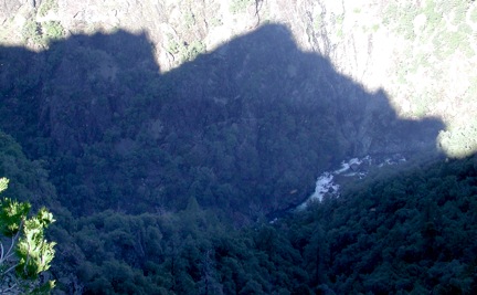
| Lovers Leap from the Pinnacles |
There is Green Valley, with its pine forest nurtured by Ice Age sediments, to the east; there is the Diving Board Ridge, and the Gold Run Diggings, to the west; Lovers Leap, in all its complexity of spur and ridge and gully, is directly across Giant Gap to the north. Lovers Leap and The Pinnacles seem to be made from the same most-massive, overturned-to-the-east zone of metavolcanic rocks of the Calaveras Complex, from which all of Giant Gap was carved, over several million years, by the mighty North Fork.
Below us, the shadows of The Pinnacles were spread across the base of the Lovers Leap cliffs, and, since we ourselves stood atop The Pinnacles, the shadow was near our anti-solar point--and we saw the same curious color-change, which one sees from Lovers Leap, in the shadow of Lovers Leap over Green Valley, namely, an odd region in which the shadow is slightly washed-out, and quite blue in color. Just below this feathered region of blue, the waters of the river boiled white as they roared loudly and careened down the chasm.
 There was no eagle puke to be seen, not even one hairy pellet. I explained to Catherine that the world is going to hell in a handbasket, and between the logging on Giant Gap Ridge, and the illegal subdivision of Moody Ridge, and the sins of modern civilization generally, the eagles had left, for wilder canyons, where bulldozers are rare, and drunken hunters even rarer. Soon after this sad educational task we were surprised to see a Golden eagle soaring near one of the larger pinnacles, well below and to the north. Within the frigid embrace of the wind it effortlessly lofted higher and soared past us, just below; we had a very good look at it.
 |
| Eagle at left |
At the truck we stashed our packs and started down an old human trail which plunges down the very axis of the main spur of Giant Gap Ridge, back down into Giant Gap. A few hundred yards brought us to a fine viewpoint, with the Pinnacles looming rather grandly to the west, and darkly silhouetted against a glowing haze of afternoon sun. Green Valley was half-covered with the shadow of Lovers Leap, and the low angle of the sunlight helped reveal details of its mostly forested topography.
Then it was back up and out, into the truck, and back to Colfax, with a few explorations along the way; we visited the top of the Blue Wing Trail, and the Iowa Hill Saloon, where some rough-looking types discussed the sluice boxes they had fixed, semi-permanently, in this or that creek, and their hidden camps.
By sunset the northeast winds had grown to near gale force, and buffeted my little pickup truck as I struggled into the teeth of it, on eastbound I-80. But then I was home, and such was a day high on the walls of Giant Gap.
Cheers,
Russell Towle
No comments:
Post a Comment