
[Russell Towle's journal]
“3/30/82 Still snowing. About 2 feet on the ground now, and still snowing. The temperature never climbed above 30° here yesterday, in outrageous blizzard conditions. I'm developing a finely tuned sense of when I must move the Toyota or face entrapment. Moved it a necessary 50 yards at dawn yesterday; after a couple of hours of very heavy snowfall, had to take it the rest of the way out (to civilization-plowed roads) or else; so I did, my front bumper spraying snow the whole way.
This storm just won't let up. Snow falls more horizontally than otherwise. I tune into the NWS, and they opine that it ‘will arrive tonight’ ~ that should be quite a show.
I've been recovering, bit by bit [respiratory ailment]. Yesterday I was energetic enough to do my laundry, do a little skiing, dig my Toyota out of the snow about 10 times (I haven't put chains on yet and it rarely occurs to me to do so)—but that was a lot. When I reached the cabin, I ate and immediately spaced out ~ slept? ~ On the couch. Awoke at midnight, to bed; tired, but not feverish.
Then, arose this morning at 4:00 AM, got into heavy shoveling of snow to reach the outhouse; then fought a frantic battle with the frozen pipes, in pre-dawn pitch darkness powered by tiny flashlight.… lost. At dawn, snapped on my skis, delighted that I had so much energy, and skied out to the cable and back. Then repacked part of the track by skiing out and back again. But by then, my right lung hurt, and I was spitting bloody phlegm. Very scary to me. I was miserable, in fact. I rolled up in Oaxaca blanket and slept from 7:30 AM to 12:00. Now the lung hardly hurts at all. No blood anymore. If it would stop snowing I would go out skiing again. Actually, it's the wind.
Pipes still frozen. Having a fire is dangerous.”
[Russell Towle's journal]
“3/30/88 afternoon of a faun, wind-blown crystal seething sharply cut and cool, sun so bright, I relinquish Seneca and Naturales Questiones and curious comments about comets, leave Suetonius and the exertions of Caesar, for my own grappling skirmishes with dead ceanothus, cleaning [their] corpses from the Grassy Knoll, peeking at peaks and a withering snowpack, observing a bold bracken fern breaking ground for its brethren, spinning lax fancies with a languid brain, about this or that project, a road of boulders here, a toolshed of boulders there, a clearing of further brush, of pines, of cedars, or maybe (shiver) just leave them well enough alone, block the wind, trap the sun; enshrine a thick and tangled copse so as to say, “Ecce! Once all was this!” ”
[Russell Towle's journal]
Date: Fri, 30 Mar 2001 08:54:16 -0800
To: North_Fork_Trails
From: Russell Towle
Subject: Adventure on the North Fork
X-Attachments: River_Trails.jpg:
Hi all,
Yesterday, Canyon O'Riley and I worked a bit on the road coming in to the Canyon Creek Trail at Potato Ravine Pass. We clipped about 100 manzanita and deerbrush branches and worked up a sweat. Then it was down the trail to the river, then upstream on the old river trail. Our objective: to see if anything like this old river trail reappeared farther up, especially, near a "particular ridge" projecting into Giant Gap from Moody Ridge, about a mile and a half upstream from Canyon Creek.
A map is attached, with contours at 100-foot intervals, bold contours every 500 feet, some contours labeled, and some points labeled. The Canyon Creek Trail is a yellow line, the two previously known reaches of river trail also yellow, the new reaches explored red, dashed where uncertain. The North Fork is a broad white line. The numbers on the sides are UTM coordinates in meters.

The (first part of the) old river trail is in pretty decent shape, after the brush clearing project of a couple of months ago. After 1/2 to 3/4 mile it leads down to the river with a branch staying high, which branch, however, is overgrown and hard to follow. We followed the river instead, for I had the strongest image in my mind, that we could boulder-hop all the way up to the particular ridge. How wrong can a person be? We soon found ourselves stopped cold by cliffs plunging right into the roaring torrent, and had to climb high to pass them. A couple of times we descended to the river, expecting to be able to follow it, but, no. No, no, no. It became a kind of exercise in gymnastics, but no matter how cleverly we passed this or that obstacle, soon enough, there was another cliff. Finally, after a lot of up-and-down and huffing and puffing and getting all hot and bothered, we gave up on the river and found the trace of a high trail.
It soon headed directly into a dense thicket of bay laurel, interwoven with poison oak. The poison oak, by the way, seems to be doing well everywhere in that district. For a while we were stopped and then said, more or less, damn the torpedoes, and picked our way through the glistening poison leaves, on a line about 50 feet below the trail itself.
As if rewarded for our pluck, suddenly the trail became even more well-marked, and there could be no doubt of it being "the" high river trail. It even had some rock work and some switchbacks, and finally descended to the river just shy of the particular ridge. Here we found an abandoned kayak and some other gear. Probably the person will come back. We did not see a paddle.
By using our imagination we could perceive that yes, just as we had hoped, a trail continued high along the particular ridge. Rock-hopping over to its base, Canyon went up into an ocean of poppies and lupine and found the high trail. It was the real deal. On we went, reaching a trash-strewn miners camp from a decade or so ago. Then on just a mite farther, and we were rewarded with a fine view up the gorge, the North Fork churning along between two cliffs. Here there was no obvious continuation of the high trail, although, to be fair, if it had continued, it would have had to have climbed another one or two hundred feet at the least. We did not climb up to look for it. The cliffs here had suddenly gained much in magnitude and steepness. At the point we reached, we were atop a 100-foot perpendicular cliff beside a deep pool. It could be called Superman Point, because, with complete disregard for safety, one could easily jump into the pool. Unfortunately the pool looks to be only about six or eight feet deep below the cliff.
The afternoon was waning, the shadows growing long, so we started back out. Where Canyon had climbed straight up, we found the trail actually itself climbed up by a nice switchback a little ways farther downstream, moreover, the trail continued past the switchback. In a little ways it reached a little flat campsite from the days of '49. Beyond there it was horribly overgrown, so we dropped back down to the river, and picked the trail we came in on, near the kayak.
Incidentally, these old miners' camps are usually tucked within the shelter of live oaks. It is amazing, almost unsettling, how little shelter there is from the sun down there, especially near the river. There are no alders or willows or cottonwoods at all to break the force of the sun. It is just rock on rock, cliff on cliff, a hundred thousand flowers on the slopes above, and the roaring, dancing, dangerous river. And the sun. Sun on sun.
For a long ways this trail is in remarkably good shape, though often overgrown. Then a critical region is reached where things become less certain. This is shown as a red dashed line on the map. There are some big blades of rock and one branch of the trail runs high to pass these. I mean, fully 400 feet above the river. Another branch runs low, but is faint. We took the high road and soon found ourselves blocked up severely by a big area of blooming buckbrush. This was, however, familiar to us, from our efforts of a month ago to find a continuation of the high trail. We adopted the same strategies to pass the brush, and soon enough found a certain ravine where, having crossed to the west side, we stopped at the "miners' tool cache," where we did some cleanup. I had brought a garbage bag for just this purpose, and gathered old batteries, a flashlight, all kinds of miscellaneous plastic, and four five-gallon plastic buckets. These had been in enough sun over however many years to have partially disintegrated, so we picked up all the scattered pieces and jammed the intact ones together, packed it all up and continued west. There remains a sleeping bag and some clothes and a foam mattress. And a bunch of tools, including two sluice boxes.
This was the last of the uncertain part of the high trail. It traverses a grove of canyon live oaks well above the river, then hits another ravine, where one must descend two hundred feet to reach the "main" old river trail. Soon we reached Canyon Creek.
The sun set as we came up the Canyon Creek Trail. We were moving slowly, it had been a real thrasher, an incredible workout. Apparently I am notorious for such adventures. The unwary accompany me on a hike. They imagine it like this: a broad, flat, shady trail, possibly downhill the entire way, and downhill on the way back as well. Without warning, they face a nightmare of cliffs and gorges and poison oak and rattlesnakes.
These old river trails are severely influenced by the topography. A cliff or a rock blade may force the trail up a hundred feet or more. A ravine may force it down fifty, then up fifty on the far side. The steeper the terrain, the bigger the rock blades, the higher the trail is above the river. We found ourselves 400 feet above the river at times. I would say with all the various ups and downs of our little 1-and-1/2-mile jaunt up the river from Canyon Creek, we added at least 1500 feet, maybe 2000 feet of vertical climb, to the rather mild 1500 feet from Potato Ravine Pass down to the river on the Canyon Creek Trail. So it was a 3000- to 3500-foot day.
The flowers are really spectacular. The poison oak is viciously robust. The sun is hot, the river is cold, the rocks are steep. Truly the North Fork American is a wonderful river. We got back to the Dutch Flat exit and saw that the waxing crescent moon was centered between two planets.
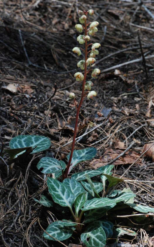
March 30, 2006
A common plant of the shady forest floor in the North Fork canyon is White-veined Wintergreen. Russ altered this photo highlighting leaf edges, and named the file "abstracted pyrola".

View a CalPhotos database image of a blooming un-abstracted White-veined Wintergreen:
http://calphotos.berkeley.edu/imgs/512x768/0000_0000/1109/1006.jpeg
I really like this bit:
ReplyDeleteWe were moving slowly, it had been a real thrasher, an incredible workout. Apparently I am notorious for such adventures. T he unwary accompany me on a hike. They imagine it like this: a broad, flat, shady trail, possibly downhill the entire way, and downhill on the way back as well. Without warning, they face a nightmare of cliffs and gorges and poison oak and rattlesnakes.
Yes -- this is the kind of excursion the initiated would later refer to as "a Russell hike". Everyone who has ever been out on a canyon jaunt with him knows just what this means. He could get you to go places and do things that you never thought you'd be able to do... and though you probably got thrashed, you would have a wonderful time, see amazing things, learn a ton, and have an experience you never forget.
ReplyDelete