Showing posts with label 2001. Show all posts

January 3 (1981, 1989, 2000, 2001, 2003, 2008)
Big Valley Bluff ~ More on the “Blasted Trail”

January 3, 2021

Several holes, dug through the duff by one of the resident critters... was it fungi or insects it was after? Is this why I am not finding mushrooms in this area? Yep, probably.


1/3/81   Way before dawn... went to the Bluff* yesterday and hiked down to the edge of the canyon. McClungs, anxious about heights, stayed above. I got hungry for quartz crystals and climbed down the cliff in search of quartz veins; I found many veins but few crystals. Clouds came in while we were there. We left after an hour or so.

It sprinkled lightly last night, the first precipitation in weeks. Incredible weather most of December—sunny, over 70° in the day, above 40° at night.”

[Russell Towle's journal]


*The "Bluff" is Big Valley Bluff, a point on the north rim of the North Fork canyon west of Snow Mountain. It is quite unusual to have been able to visit that spot on January 2nd, since the access road would normally be long blocked with snow by this mid-winter date, being over 6000' elevation. The warm, sunny December he describes in the second paragraph explains how it could be.

View to the east from the Bluff
(Click to enlarge)

View to the west from the Bluff
(Click to enlarge)

View south across to Tadpole Canyon
Straight down over "Falcon Perch" high above the river
Taken August 2, 2008, after the "American Fire" finally died out, from the Iowa Hill Ditch trail near the head of Tadpole Canyon, looking north across the North Fork to Big Valley Bluffthe highest point on the right.
(Click to enlarge)


January the 3rd, 1989

[...]

I cried while skiing up the meadow and out from my cabin today. It really seemed like good-bye. The water line is frozen, pipes are broken inside the bathroom wall, it is all a mess and a clutter and a thousand memories of so many many prayers for someone to share that incredible beauty with. So many unanswered prayers. And there comes a point when it is just too much, it has gone entirely too far, and yet the sun lights it all up as always and I cry to think of so much loneliness. It is so less than fair. Then for my father to move out there. It's over. I'm gone; if I am seen around here now, it is only my ghost. I'm out of here.

Or so I say.

The sun sets, after another clear day, so blessed after too many storms.

[...]

[Russell Towle's journal]


Date: Fri, 3 Jan 2003 08:39:41-0800
To: North_Fork_Trails
From: Russell Towle
Subject: Blasted Trail? Uhhh ... No!!!!

Hi all,

Terry Davis of the Sierra Club wrote, of Supervisor Rex Bloomfield's proposed Capitol-to-Capitol Trail,
"Bill & Russell & others, I've been horrified by Rex's trail concept ever since he started talking about it a couple of years ago. Wide, even grade, close to the river. He refused to even talk about using existing trails. He seemed to have in mind a mini super-highway, off limits only to motorized vehicles. I think that the Sierra Club, PARC, CNPS, Audubon all need to make it clear that we will not support the trail he has in mind—can you imagine blasting through the Giant Gap and the Royal Gorge? I wouldn't be so sure it's an impossible dream. Once the EIS/EIR is approved by the agencies, the grants will just roll in. We need to strategize on stopping, or modifying, this atrocity. I hate to wait until the environmental docs are out. We need to make this controversial now. Terry"
Now, others on this list have made some inquiries, and been assured by people involved in the actual planning of the trail, that:

1. It will not go through the Royal Gorge.
2. Its actual course has yet to be determined.

Hmmm. Then why did the map in the Bee article show it going right up the river?

I agree with Terry, we need to figure out how to stop this trail.

One thing we can do right now is let District Five Supervisor Rex Bloomfield know we are opposed. Perhaps the simplest message would be, "no new trail in the North Fork American canyon." That is least open to misinterpretation. His email address is:

Rex Bloomfield [no longer relevant]

He gets all these "North Fork Trails" email list messages anyway.

Cheers,

Russell Towle


Date: Fri, 3 Jan 2003 11:20:12 -0800
To: Deane_Swickard
From: Russell Towle
Subject: Re: Blasted Trail? Uhhh ... No!!!!
Cc: North_Fork_Trails


Hi Deane (Deane Swickard, Area Manager, Folsom Area, BLM),

Thanks for your reply, in which you wrote,
>
>Relax, there is no way a trail is going to be blasted up the North Fork
>American.
>
> First, it will never pass muster on environmental grounds.  It's
>inconsistent with wild river management.  There will be no blasting a trail
>along BLM or Forest Service land in the wild river corridor.  Since most of
>the river is publically owned from 1000ft above the Iowa Hill Bridge
>eastward, a trail within a quarter mile of the river doesn't have a prayer.
Yes, this seems only what good sense would imply.
>Rex has good intentions.  Trails are very popular and there is need for new
>trails throughout the state.  In this case, he seems limited a bit by his
>knowledge of the geography, the protections afforded wild rivers and the
>difficulty and cost of trail building in steep terrain.
Yes, Rex has good intentions. But the Road to Hell should by no means proceed up the North Fork of the American River!

Although it seems to me that no new trail would be allowed to be constructed within the North Fork American Wild & Scenic River corridor, nor, for that matter, within the canyon at large, this idea has been kicking around for a few years now, has not gone away, and in fact, has attracted a grant of $1.5 million from the CA Resources Agency, and a grant of $400,000 from the Placer Legacy.

It could be that Tahoe National Forest District Ranger Rich Johnson, of the Foresthill Ranger District, has provided encouragement to Rex Bloomfield, about the prospects for building a new trail, suitable for horses and mountain bikes, up the river, within Tahoe National Forest. For, Rich Johnson has said to me personally that he envisions opening up a trail from Mumford Bar, downstream to Italian Bar. Such a trail, I believe, existed in the 19th century, since I seem to recall that, in his diary, I.T. Coffin records going from Italian Bar up to Mumford Bar in 1863, along the river, which would be quite a strenuous exercise without some kind of trail to follow.

So, in this one reach of the river, it could be maintained that a trail already exists.

Similarly for the reach from Euchre Bar, upstream to Italian Bar.

I have been scouting out some of these old trails, now abandoned, but hesitate to bring them to the attention of Tahoe National Forest, lest they become mountain bike trails. I have about had it with mountain bikes in the North Fork American, especially within the Wild & Scenic River corridor.

Thanks again for your remarks, which tend to quiet my extreme terror.

All the best,

Russell Towle


April 11 (1978, 1987, 1988, 2001, 2002)
Joy, Fear, and Reverence in “The Great American Cañon”

4/11/78 […] and we went to the Leap. It was a perfect spring day, and the late afternoon sunlight displayed the canyon to its best advantage.”

[Russell Towle's journal]


4/11/87 […] I've been upset these past two weeks, after the Saturday incident. Apparently I've inspired quite a bit of disapproval because of the publicity the Big Oak at Lover's Leap has received. I don't really know how best to respond; I believe that Lovers Leap is a spot which should remain openly accessible to the general public… It is definitely not agreeable to them… the pressure of their dislike towards me is annoying and intimidating… My fantasies turn upon getting beaten or murdered or humiliated publicly, etc. etc. I consider moving away. And perhaps I shall. But this is not why I sat at my typewriter this Friday morning in April, this balmy flowering hazy spring day.

[…]

[Russell Towle's journal]


4/11/88 Evening; windows open upstairs and down, incredibly warm weather […]

So I awoke bleary and ill-humored and without proper fixings for my morning coffee and short on time since I had to wash my clothes and wash myself and prepare for my meeting with the Forest Service. I stopped by Bill Newsom's and imposed upon him various burdens, coffee, washing machine, dryer, shower, while helping him with this and that.

Met The Peach in Colfax and on to Nevada City we went, arriving early at Forest Service headquarters and spending some time talking with one of the timber people, Don, about various harvests being planned.

Then the long-awaited Meeting, attended by Frank Waldo, Truckee district ranger JoAnn, recreation officers Pete Brost Matt, plus a delightful fellow named John, old and wise, TNF lands officer, quite knowledgeable and expert and reasoning; and we looked over the Royal Gorge trail system in detail, their permit status with TNF, the various ski tours lost to the Royal Gorge, and more importantly, the general and underlying issue of to what degree the public has acquired an inalienable right to use old roads and trails in the high country… Also parking, the lack of, etc. etc.

We thrashed about for some two hours, and I wished Gene Markley had been there, with some of his friends, as had been the idea. Gene et. al. weren't able to make the daytime meeting. I believe I made my case well, albeit encountering some resistance, even scorn, from Pete Brost—“What do you want? Do you think the Forest Service should step into the breach and fight your legal battles for you whenever a road is closed?” Or, “Here you are, complaining to us about the Royal Gorge, when you don't know the first thing about their operation. Why don't you contact John Slober (Royal Gorge owner) and express your concerns to him? Instead of talking about something you are ignorant of.”

However, all in all, I made my case well, to what discrete or tangible effect I've no idea, but, by a sort of addition of vectors, not a merely wasted effort.”

[Russell Towle's journal]


April 11, 2001


The Great American Cañon
Russell Towle

From
The Pacific Tourist, 1876:
“… a few miles beyond, near Shady Run, there suddenly opens on the gaze of the expectant traveler, just before the sunlight has quite disappeared, and the evening shades come on, the vision of The Great American Cañon—by far the finest cañon of the entire Pacific Railroad. The suddenness of approach, and the grandeur of scene are so overpowering, that no pen, picture or language can give it adequate description. Two thousand feet below, flow the quiet waters of the American River. Westward is seen the chasm, where height and peak and summit hang loftily over the little vale. …”
[View The Pacific Tourist in entirety here:
http://cprr.org/Museum/Books/Williams_Pacific_Tourist.html ]
“Don’t tell anyone,” they say; “keep it a secret. If people find out, it will only get ruined.”
All too true; but it’s being ruined, slowly but surely, anyway. There is a Yosemite hidden in our own back yard, over 3000 feet deep for miles and miles, with 500-foot waterfalls and eagle eyries, ancient petroglyphs and monstrous pines. It is the Great American Cañon, once famous nationwide; the canyon of the North Fork of the American River.

No one can drive into this Yosemite. It is riven into slates and other metamorphic rocks, rather than that porridge of crystals we call granite, and it must be this slatiness which explains its unusual depth. Northern Sierran canyons are much of a muchness, having been cut by rivers of similarly-sized basins, into a sloping plateau of volcanic mudflow. Our flat-topped ridges are vestiges of this plateau surface. Yet, at a distance of ten to fifteen miles from the Sierra crest—say, west of Kingvale on I-80—we find the South Yuba flowing over granite at an elevation of 6000 feet, while a few miles to the southeast, the North Fork American runs at 3500 feet, through metamorphic rock.

No roads cross the North Fork from near Colfax on the west, to The Cedars, on the east, a distance of over thirty miles; and little wonder. It is too deep and too steep. Historic trails, dating from mining days, offer access to the sparkling river; but relatively few people are prepared to take on a canyon over 3000 feet deep. There is the Palisade Creek Trail, from Cascade Lake; the Big Granite Trail, from near Salmon Lake; and the Mumford Bar Trail, from Sawtooth Ridge: these enter the canyon from the north. From the south, along the Foresthill Divide, we have the Sailor Flat, Beacroft, Mumford Bar, and Italian Bar trails. Mark all these down as strenuous; farther west, where the canyon shallows somewhat, the Euchre Bar and Green Valley trails descend a scant 2000 feet. Few consider that an easy hike.

Most of this spectacular reach of the North Fork American is within the boundary of Tahoe National Forest (TNF). However, the railroad land grants of the 1860s left the area in a “checkerboard” land ownership pattern. For years now, TNF has pursued land acquisitions along the North Fork, in an attempt to forestall logging and road-building in this remarkable canyon. Most of the old railroad lands recently passed into the hands of lumber companies.

At this moment Tahoe National Forest is seeking Land & Water Conservation Act funding to acquire 6100 acres of land owned by Sierra Pacific Industries in the North Fork canyon. Letters supporting this purchase are desperately needed, to Representative John Doolittle, and Senators Barbara Boxer and Diane Feinstein, right now. Go to http://personal.neworld.net/~rtowle/NorthFork/Environmental/Environmental.html [link is no longer active] for addresses and more information about North Fork land acquisitions.

If you write a letter I will tell you another secret: The Great American Cañon has its own El Capitan. It is called Big Valley Bluff, and stands 3500 feet above the river. Go to a ranger station, get a Tahoe National Forest map, and from Emigrant Gap on I-80, follow Forest Road 19 for miles and miles through various valleys, until, having climbed from the East Fork of the North Fork of the North Fork American onto Texas Hill, you lose the pavement and the road forks. To the right is the road to Sawtooth Ridge and Helester Point; to the left is Big Valley Bluff. In about four miles, a right fork to the Bluff itself is met, which is about a mile to the south. This last stretch can be a little chancy in a low-slung passenger car. In any case, Forest Road 19 will not open until the snow melts, some time in May. Aim to reach Big Valley Bluff in the afternoon, when shadows grow long. Watch for falcons and golden eagles.

So, go to Big Valley Bluff; wander the cliff-tops, watch the sunset. It would take years to know the Great American Cañon well, but how better can one live a life on this quickly shrinking Earth? Discover for yourself why the old guidebooks to California so exalted this one canyon, and why there was once a movement to name one of its many gorges after God Himself: “Jehovah Gap,” near Alta. However, the old Gold Rush-era name, Giant Gap, stuck. Here an illegal subdivision in the 1970s created “view parcels” which now sport houses visible from far and wide. I hear the new residents wish to call it “Giant Ego Gap.” To avoid similar atrocities in the upper canyon, we should support Tahoe National Forest in its land acquisition efforts.


An April storm leaves fresh snow down to 2500' on the
North Fork American River canyon slopes.
April 11, 2001


Date: Thu, 11 Apr 2002 10:27:18 -0800
To: North_Fork_Trails
From: Russell Towle
Subject: Stevens Trail, Iowa Hill side


Hi all,

I spoke with Deane Swickard of Folsom BLM the other day, and learned that negotiations have been successful with property owners near the head of the Stevens Trail at Iowa Hill. The upper end of the trail will be relocated, and a BLM work party is scheduled for Monday the 15th of April, meeting at the Iowa Hill store at 10:00 A.M.

So, this is good news. I am going to try to attend the work party. Over very much of its length this trail is very gently graded, in fact, it takes almost too long to reach the North Fork. It offers a tremendous contrast, vegetation-wise, to the Stevens Trail on the Colfax side, for the Iowa Hill side is often on north-facing slopes, and is very mossy and shady and ferny.

In my conversation with Deane I learned that no plans are afoot to make any acquisitions at Gold Run; there is no money, says Deane; we need Land & Water Conservation Act funding. Well, this is not such an easy thing. In fact, it really puts land acquisition at Gold Run way out there, somewhere in Never-Never Land.

[...]


April 6 (1978, 1979, 1988, 2001, 2007)
Snow and Deer and Eagles

4/6/78   mid-day. i awoke this morning to the heaviest snowfall of the season. about a foot is on the ground and it is still snowing. a little while ago i walked up to the meadow; my trail is blocked by snow-laden ceanothus, but i was able to go over the brush piles blocking my old road. i decided it would be interesting to see if willy would make it out to the cable and back, so off i went. out to the cable was easy, but as usual the last grade coming back in was no go. i tried several times and finally got willy stuck, skewed half off the road, and managed to tear the body of the cab in a couple of places where it had been welded together years ago by craig. the transfer case (?) started making ominous sounds and the engine would not idle but raced. so I don't know the extent of the damage yet, but it may be extreme. i may have turned willy into a piece of junk. at any rate, the trip to auburn for the forest service presentation of their recommendations about the North Fork vis-à-vis national wild and scenic river designation is out.”

[Russell Towle's journal]


4/6/79 morning, rain and fog, after a week of delightfully sunny warm days. last night this storm marked the onset of rain with a nice barrage of thunder and lightning. the closest strike was three thousand feet away.”

[Russell Towle's journal]


4/6/88
This morning I was deer-watching in the yard, and heard, for the first time, deer speaking in normal tones to one another—for I've heard before their cries of distress, and their coughing barks—but these sounds were like the creaking of chairs, a sort of humming nasal buzz, faintly goat-like, not at all loud; one group was greeting another which approached, and responded alike, back and forth they spoke, without opening their mouths, in a kind of ventriloquy.”

[Russell Towle's journal]


Date: Fri, 6 Apr 2001 19:55:43 -0800
To: North_Fork_Trails
From: Russell Towle
Subject: Gold Run Addition


Hi all,

I spoke with Mark Pohley, one of the principals of Gold Run Properties (GRP), this evening. I told Mark that I had asked Senator Boxer to sponsor a bill seeking LWCF money to purchase 357 acres of the GRP holdings near Gold Run, which include much of the Canyon Creek Trail, along with two parcels along the line of the Giant Gap Trail near Bogus Point, and the main deep pit in the Gold Run diggings.

Mark said that the property, comprising 800 acres, is still for sale, and that they have reduced the price somewhat, but thus far, have had no meaningful offers. He also said that, during the annual meeting of GRP, they had discussed the possibility of selling most of the 800 acres to (hypothetically) Placer Legacy, and donating the balance.

I am encouraged by Mark's attitude, and, given that the property in question for the most part is within the Gold Run Addition to the North Fork American Wild & Scenic River, and thus has been a desired acquisition target for the BLM for over twenty years, I think that if a goodly amount of public support can be generated for this acquisition, it can and will happen.

Letters of support to Senator Boxer will be crucial. There are a number of different potential "letter objectives" which occur to me, probably many more will occur to you. Here are some of my ideas:

1. Placer County Board of Supervisors.
2. Placer Legacy.
3. Dutch Flat Community Club.
4. Sierra Club.
5. PARC.
6. Friends of the River.
7. Colfax Chamber of Commerce.

Well, that's all the news I have at present. Oh, yeah. The weather does not look promising for the Native Plant Society hike into Canyon Creek tomorrow. It's very probably a no-go.

Cheers,


Eagles on the Nest
[North Fork Trails blogpost, April 6, 2007
http://northforktrails.blogspot.com/2007/10/eagles-on-nest.html ]
View eastward from Lovers Leap, Moody Ridge
Early this morning I drove out to Lovers Leap with camera and binoculars. I had a pretty good idea of where the Golden Eagle nest ought to be, not far from the Joint Plane which drops arrow-straight to the river from the V-notch on Pinnacle Ridge. First I scanned the main Lovers Leap Spur in search of Peregrines, but saw nothing.

Then I braced my arms on my knees and carefully scanned the area around the Joint Plane, just above where it drops out of view behind the nearby Spur, perhaps 800 feet above the river, across the Gap from the Leap. I saw a tangle of dead branches beneath a rock overhang, and thought maybe I had it.

But no.

Ten minutes after my arrival, without having noticed any falcons in the air, I saw a Peregrine right below me on the Spur, on what I call the Second Step. It was silhouetted against the dark shadows which held everything across the river in their thrall, everything except the highest pinnacles. It clearly knew I was there; whenever I scooted out into plain view to get a really good look, it turned its head to fix me in the gaze of its right eye. It did not leave its sunny perch.

After a time, Deren Ross of Auburn quietly arrived, with his spotting scope, and we obtained incredible views of the falcon, every feather in focus, every subtlety of color revealed. I could see sun, sky, and canyon, all reflected in its eye, for goodness' sake. Then Deren put the scope on the eagles' nest, and I was amazed, it was scarcely a hundred feet from the false nest, but I doubt anyone, using binoculars, would spot it, unless the eagles were actually arriving or leaving. An adult eagle was on the nest, turning around from time to time. I could not see egg or eaglet. I never saw the mate.

Look close to see the man with the spotting scope on the ledge
The nest was beneath a small overhang, on steep north-facing cliffs, perhaps sixty or a hundred feet east of the Joint Plane. It was made of a mass of dead grey branches, four or five feet in diameter. I expect it was lined with the club moss which coats many rock surfaces in the Gap.

Clouds of Violet-Green Swallows and White-Throated Swifts circled over the cliffs below us, and a Kestrel, or Sparrow Hawk, the smallest of our falcons, came whirring by, scarcely twenty feet away, beating its reddish wings rapidly, climbing slowly. Occasionally we heard a Canyon Wren.

Late in the afternoon I enticed my son, Greg, out to some little cliffs, hoping to see some distant eagles or falcons. We saw nothing; well, there were more or less spectacular thunder-clouds over the high country, with rain showers drifting down, and bright-glowing snowfields on Snow Mountain. We could see the Iowa Hill Canal, east of Tadpole Canyon. But no falcons, no eagles.

Greg picked up a massive pine cone, from a tall and old Digger Pine leaning over us, and gave it a toss down the cliff. We could hear it rolling down the canyon wall for quite a long time. This scared up a few Band-tailed Pigeons, who flapped around noisily before landing in various trees. One seemed to immediately leave its chosen tree, typical pigeon behavior, but at once I saw it was larger, and put my binoculars on it.

After all that time looking for distant eagles, one had been roosting in a Douglas Fir maybe two hundred feet away, the whole time we were there! It soared west, with a few lazy flaps, and then plunged out of sight, making for a rabbit, snake, or squirrel, I would guess. It looked to be a yearling, with a hint of white left in its tail.

Such were some fine experiences in the Great American Canyon.

Golden eagle nest at Giant Gap, April 6, 2007


April 5 (1978, 2001, 2007)
Groundcones and Raptors

4/5/78 yesterday i hiked over to casa loma on the tracks, which have incredible views of giant gap and moody ridge. the clouds were breaking up, magnificent billows, shafts of light making patchwork in the canyon. the black oaks are getting their leaves now, and when a patch of light fell on one of the groves with the surrounding slopes in shadow, it was incredible. i stopped in at ron's and contemplated his latest watercolor for a while; soon gary stopped by and we all walked back down onto the tracks. oh but for a camera! when i returned in the late afternoon, i made some tacos and walked out to the rock outcrop to watch the last light of the day. only a couple of patches were lit in the canyon, although near the royal gorge a large snowy slope was illuminated. the sky had cleared overhead, but in the east were gigantic upwelling cumulus clouds that were quite colorful. the central tower could be seen to rise and expand slowly as it got rosier and rosier; i thought i detected a slight counter-clockwise rotation as well. the glory of it all.”

[Russell Towle's journal]


California Groundcone
( Boschniakia strobilacea)
Date: Wed, 4 Apr 2001 23:02:06 -0800
To: North_Fork_Trails
From: Russell Towle
Subject: California Groundcone

Hi all,

I ventured out today to the head of the Pickering Bar Trail in search of the California Groundcone. It is in bloom. [Also] a species of paintbrush; the Chaparrall Virgin's Bower; and the Harlequin Lupine.

This "Groundcone" is an interesting plant, and quite easy to miss. It looks like a little Douglas Fir cone sticking up out of the ground, always under manzanita bushes. Why manzanita, you say? Because it is parasitic, and attaches itself to the manzanita roots. It has no chlorophyll, and is in the Broomrape family. It is reddish brown. A type specimen for the Jepson Herbarium was collected at Gold Run in 1931; I have only seen it there, and near Secret Ravine, a few miles west, but, not only is it widespread, it has been found from near sea level up to 10,000 feet! Amazing in itself.

[...]

Groundcone in bloom
We visited The Bluffs, off Garrett Road, and found that some four-wheel-drive yahoos had spun donuts in the parking area until they wore down to the root level. Mud was splattered on the pines nearby over six feet from the ground.

The weather is not looking good for the Native Plant hike this Saturday. If it rains we'll probably not do it.

Virgin's Bower
(Clematis lasiantha)
Harlequin Lupine
(Lupinus stiversii)
Paintbrush
(Castilleia ?)


Peregrines in Giant Gap
[North Fork Trails blogpost, April 5, 2007:
http://northforktrails.blogspot.com/2007/10/peregrines-in-giant-gap.html ]
This afternoon I ventured out to Lovers Leap in search of raptures, I mean, raptors, and found two men spellbound, gazing into the depths. All day it had been cloudy, the canyon dull and flat, shadowless, but as the afternoon waned the sun broke through. Thus the Pinnacles were sharply lit, and shadows deepened, offering more and more contrast, and many of the Sierran snowfields far to the east were luminous, etched whiter than white against the softer pastels of the clouds.

The men had hiked and climbed in the Sierra together since childhood. They contemplated a trip down to Green Valley. I began to expound upon the theme of Green Valley, and unleashed a torrent of words, while the North Fork's own dwindling torrent roared two thousand feet below us. I also told them of the Peregrine Falcons and Golden Eagles, but we saw none, though one of them remarked he had seen a Peregrine, while visiting Lovers Leap recently.

I had never ever seen one, anywhere.

After a time the men left, and I heard their voices as they ascended the steep trail; which way, one asked, go left, the other replied. Then their voices seemed to get louder, and again it was which way, but, go right was the reply. Then some excited nonsense about having a magical birthday, on the very equinox, and in olden times the Druids would have felt such a birthday must count for a lot, and so on and so forth, and lo! three teenagers shouldered through the blooming brush.

They were from Auburn, I found, and soon enough I was expounding upon the landscape, and it was not enough to say, "over here is Little Bald Mountain, and away over there, the Coast Ranges north of San Francisco," but, no, I must tell these young men of equinoctial birth about townships, sections, ranges, and Mt. Diablo, and how, since we were in fact within Township 15 East, Range 10 North, this meant we were "something like" six times fifteen miles east, and six times ten miles north, of the Diablo summit.

Which made perfect sense to me, and might have made more sense to them if we had been able to actually see the Diablo summit; but there was too much haze and moisture in the air.

I also explained to them about the falcons and eagles, and soon their sharp teenage eyes picked out a Peregrine, a mere dot of light against some vast canyon shadow, and I whipped my binoculars to my eyes, and, sure enough, there it was, my first Peregrine Falcon.

My overall impression was of a soaring bird, with much blue-grey, but with flashes of white, and not as big as a Red-Tailed Hawk.

It, or its mate, soared by several times, often a thousand feet below us, often seeming to move slowly, but in fact moving very quickly. This is also the case with the Golden Eagles; one sees them soaring so calmly, so effortlessly, yet in less than a minute they have moved a mile.

It was a very nice visit to Lovers Leap.

I was sad to see, however, that the whole area looks beaten up by OHVs, that many trees have been cut using chainsaws, that even the historic Incense Cedar logs lying athwart the trail down to the cliff have been sawn through, and the very sculptural root masses hauled away. I have suggested to the Bureau of Land Management, for quite a few years now, that a vehicle closure on the last couple hundred yards of road would be a good thing. All parking could be held to the north, before that last rise to the current parking area. Further depredations with chainsaws would be much less likely.

Finally, I now hear there is a Golden eaglet in the nest, down in the Gap, across from the Leap.


March 31 (1984, 1993, 2001, 2002, 2011)
Survivors. And a Circumambulation.

3/31/84    Morning. 'Tis snowing. Kelley and I actually skied and hiked down to the waterfalls on the North Fork below point 6868, after having traversed point 7373.
...

I went to work on the Lovers Leap project. Brad Welton of TPL has suggested that I contact the property owners at Lover's Leap, so I went out there to check on the telephone numbers for the brokers handling D. Ortega's parcel, and decided to head on out to the Leap for a quick look around. I found that someone had tried to block off the trail with logs, and the tracks of a pickup truck were in the vicinity. ...

The following day, I called E. G., the owner of the two 20s beside Lovers Leap. Talked to his wife, who assured me he has no intentions of selling. I did not mention the logs.

The realtors no longer list Ortega's property, and his telephone is unlisted. O. and L. are unlisted as well; so I wrote short letters to each, inquiring if their Moody Ridge land were for sale.
...

When I finally talked to Jerry M. at DFG, it was disturbing: the state wild and scenic program for the North Fork has been seriously weakened. The timber industry is strong. Ouch.”

[Russell Towle's journal]


Below, 18 years later, are the very early shoots of that same cluster of Hound's Tongue plants as in the photo above, with a Kellogg's Black Oak acorn for scale. 
I photographed these shoots on March 17 of this year (2011). They are right in the middle of the yard below the “Little Cabin,’ in a high traffic area. When the kids were little we would ring them with small boulders to try to protect them during the bloom season, because they have gotten accidentally tromped on, and rolled over, have had branches, hoses, etc. dragged across them (notice the hose in the background) many times over the years! They do not suffer from the abuse. They thrive. They return year after year inexorably, brightening our world, just doing what they do, in the place where they are, just... perfect.
So, the day after I photographed those early shoots by the acorn, it began to snow. And it snowed almost every day through the 27th. It has been a mega snow year—the second greatest snow-on-the-ground depth in my 30 winters on Moody Ridge. (The first was 1982; see Russ's journal post about that snow year, on March 30). 
Those new shoots remain under the rapidly melting snow this morning. I look forward to seeing them reappear, to see what they have been doing for the last couple of weeks under there. I'll post a photo.

—Gay, March 31, 2011

March 31, 2001

Ceanothus Silkmoth
(Hyalophora euryalus)

Date: Sun, 31 Mar 2002 08:16:42 -0800
To: North_Fork_Trails
From: Russell Towle
Subject: Circumambulation

Hi all,

Chris Schiller and I met at the Dutch Flat exit and made for Canyon Creek. With the last road into the diggings blocked, we had to go by way of Garrett Road, the Bluffs, and the Paleobotanist Trail. I fired up my GPS unit, hoping to obtain a good "track" record for the Paleobotanist and Canyon Creek Trails, with an accurate measure of the distances. I set the GPS unit to record points on the track every 1/100th of a mile, and off we went.

From the Bluffs to Potato Ravine Pass, where the Canyon Creek Trail itself begins, is .8 mile. Taking this as zero:
The trail soon joins the Indiana Hill Ditch, and leaves the ditch at .15 mile.
The Old Wagon Road is met at .35 mile.
The bridge across Canyon Creek, .65 mile.
The upper trail to the Terraces, 1.1 mile.
The great viewpoint over the river, looking east from a clifftop, 1.25 mile.
The end of the trail, where Canyon Creek meets the North Fork, 1.35 mile.

These results are somewhat suspicious. They do agree with previous GPS work I have done there, but, for instance, from the "great viewpoint," to the end of the trail is surely more than .1 mile, a mere 528 feet. It is true that these distances are measured on the horizontal, whereas the trail is quite steep in this area, so that on that count alone the actual trail distance is greater. For instance, from a geometrical standpoint, were the trail at a 45 degree angle, the actual trail distance would be exactly 1.4142135... times its horizontal projection. However, nowhere is the trail anywhere near 45 degrees.

On the way down, Chris and I visited the Inner Gorge, using the Six-Inch Trail. Here Canyon Creek has cut a deep twisting slot, with waterfalls hidden within the depths. Unless one were to rappel down, there appears to be no way to enter this part of Canyon Creek. The Inner Gorge ends at the top of the Big Waterfall. Most of the rest of Canyon Creek is itself quite gorge-like, but the Inner Gorge is strangely deep and beyond human reach. One can do little more than peer into parts of it and marvel.

We continued down to the river, noting the cliff swallows speeding about, and a pair of raptors gliding in the sun, their shadows sweeping over us. The river is of course quite high and cold, foaming, rushing, impetuous, and dangerous, with the warm weather melting the snow so quickly.

We decided to make a bit of an adventure out of our hike, leaping across Canyon Creek just above the last waterfall, where it slides through a narrow channel in the polished rock. We picked up the down-river trail, a sometimes faint-to-invisible relic of the 49ers, but bolstered here and there by dry-laid stone walls old enough to be hidden within masses of moss. This trail stays a hundred feet or so above the river, passing a deep pool, and drops back to the river near the base of Indiana Ravine. In effect we had rounded the base of the Diving Board Ridge.

Here we stopped for lunch. In spring-fed rock pools flanking the tumultuous roaring river, Foothill Yellow-Legged Frogs were active and abundant. We began to pass through zones of strongly foliated rock, in places folded into kinks and chevrons. We were either at, or nearing, the contact between the meta-volcanics to the east and the meta-sediments to the west, of the Calaveras Complex of late Paleozoic rocks, cut by the North Fork here. The canyon widens dramatically here, offering room for a large accumulation of Pleistocene, late-ice-age gravels. The main mass of these is at Pickering Bar, directly across the river from us, but on our side of the river there were, locally, significant vestiges of these same gravels. They have been mined quite heavily in places.

We kept our eyes open for the Pickering Bar Trail, but could not see where it came down to river level. Soon enough, cliffs forced us to climb away from the river's edge, though, and we soon found the trail. It forks both up- and down-river at its base. We found the remains of a tiny stone cabin, probably dating from the Gold Rush, on a flat terrace of Pleistocene gravels about a hundred feet above the river. From there we explored a trail leading downstream, and gained a nice view of the river, as it passes Sheldon Ravine, still another ravine with its headwaters high above us, in the Gold Run Diggings.

The early afternoon was amazingly warm, almost hot, as we began the climb up the Pickering Bar Trail. This trail is mostly quite steep. If you think the Canyon Creek Trail is steep, try this puppy out. It has an unrelenting, numbing, pitiless steepness to it, rarely equaled elsewhere. Traces of a lumber slide may be seen near the trail, which follows a ridge-crest just east of Sheldon Ravine.

The upper part of the trail closely parallels Sheldon Ravine, and at one point a game trail leads over to the little creek. It is incised into to slate-like rock rather deeply; a mini-gorge. Once it carried thousands of cubic yards of mine tailings from the diggings to the North Fork. Now it is a little symphony of rock and moss and ferns and waterfalls, with ancient Canyon Live Oaks spreading their gnarled, moss-dark branches overhead.

High on the trail a mass of very tough, very siliceous rocks threaded through and through with quartz veins is passed, and then just above, a small fire some fifteen years ago brought a bulldozer down the trail, more or less ruining its uppermost reaches, and spawning a dense mass of manzanita. Here I had the novel idea of leaving the trail and forging through the wilderness, to find a supposed shortcut to the road above. Well, this took forever, but eventually, all hot and bothered, we did reach the road, then entered the diggings and, passing the spot where the largest piece of petrified wood left in Gold Run was stolen a few years ago—a petrified tree trunk about fifteen feet long and two or three feet thick—we climbed up and out of the diggings, to a point on Garrett Road just south of where we had parked.

Thus we completed a circumambulation of the Diving Board Ridge. Perhaps not quite as impressive as, say, the ritual circumambulation of Mt. Kailas, a 22,000-foot peak in the Himalayas, near the sources of both the Ganges and the Brahmaputra rivers, said circumambulation being performed at about the 14,000-foot level by pilgrims from India — no, not that impressive, but a fine feat, of limited scope, on a beautiful day. Probably about six miles all told.

Cheers,

Russell Towle


March 30 (1981, 1982, 1988, 2001, 2006)
Superman Point

3/30/81 clear skies and fresh powder up above. There I will soon be, on my skis, gazing about the wilderness.…”

[Russell Towle's journal]


3/30/82   Still snowing. About 2 feet on the ground now, and still snowing. The temperature never climbed above 30° here yesterday, in outrageous blizzard conditions. I'm developing a finely tuned sense of when I must move the Toyota or face entrapment. Moved it a necessary 50 yards at dawn yesterday; after a couple of hours of very heavy snowfall, had to take it the rest of the way out (to civilization-plowed roads) or else; so I did, my front bumper spraying snow the whole way.

This storm just won't let up. Snow falls more horizontally than otherwise. I tune into the NWS, and they opine that it ‘will arrive tonight’ ~ that should be quite a show.

I've been recovering, bit by bit [respiratory ailment]. Yesterday I was energetic enough to do my laundry, do a little skiing, dig my Toyota out of the snow about 10 times (I haven't put chains on yet and it rarely occurs to me to do so)—but that was a lot. When I reached the cabin, I ate and immediately spaced out ~ slept? ~ On the couch. Awoke at midnight, to bed; tired, but not feverish.

Then, arose this morning at 4:00 AM, got into heavy shoveling of snow to reach the outhouse; then fought a frantic battle with the frozen pipes, in pre-dawn pitch darkness powered by tiny flashlight.… lost. At dawn, snapped on my skis, delighted that I had so much energy, and skied out to the cable and back. Then repacked part of the track by skiing out and back again. But by then, my right lung hurt, and I was spitting bloody phlegm. Very scary to me. I was miserable, in fact. I rolled up in Oaxaca blanket and slept from 7:30 AM to 12:00. Now the lung hardly hurts at all. No blood anymore. If it would stop snowing I would go out skiing again. Actually, it's the wind.

Pipes still frozen. Having a fire is dangerous.”

[Russell Towle's journal]


3/30/88   afternoon of a faun, wind-blown crystal seething sharply cut and cool, sun so bright, I relinquish Seneca and Naturales Questiones and curious comments about comets, leave Suetonius and the exertions of Caesar, for my own grappling skirmishes with dead ceanothus, cleaning [their] corpses from the Grassy Knoll, peeking at peaks and a withering snowpack, observing a bold bracken fern breaking ground for its brethren, spinning lax fancies with a languid brain, about this or that project, a road of boulders here, a toolshed of boulders there, a clearing of further brush, of pines, of cedars, or maybe (shiver) just leave them well enough alone, block the wind, trap the sun; enshrine a thick and tangled copse so as to say, “Ecce! Once all was this!” ”

[Russell Towle's journal]


Date: Fri, 30 Mar 2001 08:54:16 -0800
To: North_Fork_Trails
From: Russell Towle
Subject: Adventure on the North Fork
X-Attachments: River_Trails.jpg:

Hi all,

Yesterday, Canyon O'Riley and I worked a bit on the road coming in to the Canyon Creek Trail at Potato Ravine Pass. We clipped about 100 manzanita and deerbrush branches and worked up a sweat. Then it was down the trail to the river, then upstream on the old river trail. Our objective: to see if anything like this old river trail reappeared farther up, especially, near a "particular ridge" projecting into Giant Gap from Moody Ridge, about a mile and a half upstream from Canyon Creek.

A map is attached, with contours at 100-foot intervals, bold contours every 500 feet, some contours labeled, and some points labeled. The Canyon Creek Trail is a yellow line, the two previously known reaches of river trail also yellow, the new reaches explored red, dashed where uncertain. The North Fork is a broad white line. The numbers on the sides are UTM coordinates in meters.


The river is flowing pretty high and clear and cold; a lot of snowmelt, with the warm weather.

The (first part of the) old river trail is in pretty decent shape, after the brush clearing project of a couple of months ago. After 1/2 to 3/4 mile it leads down to the river with a branch staying high, which branch, however, is overgrown and hard to follow. We followed the river instead, for I had the strongest image in my mind, that we could boulder-hop all the way up to the particular ridge. How wrong can a person be? We soon found ourselves stopped cold by cliffs plunging right into the roaring torrent, and had to climb high to pass them. A couple of times we descended to the river, expecting to be able to follow it, but, no. No, no, no. It became a kind of exercise in gymnastics, but no matter how cleverly we passed this or that obstacle, soon enough, there was another cliff. Finally, after a lot of up-and-down and huffing and puffing and getting all hot and bothered, we gave up on the river and found the trace of a high trail.

It soon headed directly into a dense thicket of bay laurel, interwoven with poison oak. The poison oak, by the way, seems to be doing well everywhere in that district. For a while we were stopped and then said, more or less, damn the torpedoes, and picked our way through the glistening poison leaves, on a line about 50 feet below the trail itself.

As if rewarded for our pluck, suddenly the trail became even more well-marked, and there could be no doubt of it being "the" high river trail. It even had some rock work and some switchbacks, and finally descended to the river just shy of the particular ridge. Here we found an abandoned kayak and some other gear. Probably the person will come back. We did not see a paddle.

By using our imagination we could perceive that yes, just as we had hoped, a trail continued high along the particular ridge. Rock-hopping over to its base, Canyon went up into an ocean of poppies and lupine and found the high trail. It was the real deal. On we went, reaching a trash-strewn miners camp from a decade or so ago. Then on just a mite farther, and we were rewarded with a fine view up the gorge, the North Fork churning along between two cliffs. Here there was no obvious continuation of the high trail, although, to be fair, if it had continued, it would have had to have climbed another one or two hundred feet at the least. We did not climb up to look for it. The cliffs here had suddenly gained much in magnitude and steepness. At the point we reached, we were atop a 100-foot perpendicular cliff beside a deep pool. It could be called Superman Point, because, with complete disregard for safety, one could easily jump into the pool. Unfortunately the pool looks to be only about six or eight feet deep below the cliff.

The afternoon was waning, the shadows growing long, so we started back out. Where Canyon had climbed straight up, we found the trail actually itself climbed up by a nice switchback a little ways farther downstream, moreover, the trail continued past the switchback. In a little ways it reached a little flat campsite from the days of '49. Beyond there it was horribly overgrown, so we dropped back down to the river, and picked the trail we came in on, near the kayak.

Incidentally, these old miners' camps are usually tucked within the shelter of live oaks. It is amazing, almost unsettling, how little shelter there is from the sun down there, especially near the river. There are no alders or willows or cottonwoods at all to break the force of the sun. It is just rock on rock, cliff on cliff, a hundred thousand flowers on the slopes above, and the roaring, dancing, dangerous river. And the sun. Sun on sun.

For a long ways this trail is in remarkably good shape, though often overgrown. Then a critical region is reached where things become less certain. This is shown as a red dashed line on the map. There are some big blades of rock and one branch of the trail runs high to pass these. I mean, fully 400 feet above the river. Another branch runs low, but is faint. We took the high road and soon found ourselves blocked up severely by a big area of blooming buckbrush. This was, however, familiar to us, from our efforts of a month ago to find a continuation of the high trail. We adopted the same strategies to pass the brush, and soon enough found a certain ravine where, having crossed to the west side, we stopped at the "miners' tool cache," where we did some cleanup. I had brought a garbage bag for just this purpose, and gathered old batteries, a flashlight, all kinds of miscellaneous plastic, and four five-gallon plastic buckets. These had been in enough sun over however many years to have partially disintegrated, so we picked up all the scattered pieces and jammed the intact ones together, packed it all up and continued west. There remains a sleeping bag and some clothes and a foam mattress. And a bunch of tools, including two sluice boxes.

This was the last of the uncertain part of the high trail. It traverses a grove of canyon live oaks well above the river, then hits another ravine, where one must descend two hundred feet to reach the "main" old river trail. Soon we reached Canyon Creek.

The sun set as we came up the Canyon Creek Trail. We were moving slowly, it had been a real thrasher, an incredible workout. Apparently I am notorious for such adventures. The unwary accompany me on a hike. They imagine it like this: a broad, flat, shady trail, possibly downhill the entire way, and downhill on the way back as well. Without warning, they face a nightmare of cliffs and gorges and poison oak and rattlesnakes.

These old river trails are severely influenced by the topography. A cliff or a rock blade may force the trail up a hundred feet or more. A ravine may force it down fifty, then up fifty on the far side. The steeper the terrain, the bigger the rock blades, the higher the trail is above the river. We found ourselves 400 feet above the river at times. I would say with all the various ups and downs of our little 1-and-1/2-mile jaunt up the river from Canyon Creek, we added at least 1500 feet, maybe 2000 feet of vertical climb, to the rather mild 1500 feet from Potato Ravine Pass down to the river on the Canyon Creek Trail. So it was a 3000- to 3500-foot day.

The flowers are really spectacular. The poison oak is viciously robust. The sun is hot, the river is cold, the rocks are steep. Truly the North Fork American is a wonderful river. We got back to the Dutch Flat exit and saw that the waxing crescent moon was centered between two planets.


March 30, 2006
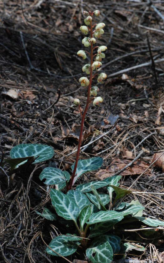
A common plant of the shady forest floor in the North Fork canyon is White-veined Wintergreen. Russ altered this photo highlighting leaf edges, and named the file "abstracted pyrola".

View a CalPhotos database image of a blooming un-abstracted White-veined Wintergreen:
http://calphotos.berkeley.edu/imgs/512x768/0000_0000/1109/1006.jpeg


March 29 (1979, 1981, 1988, 2001, 2004)
Hound's Tongue and Tufted Poppy ~ Euchre Bar footbridge

3/29/79   although the stars were visible last night, this morning a solid sheet of grey covers the sky…

i was going to take a walk, as the clouds were breaking up and i haven't been out hiking around for a while. however, thoughts about the necessity for self-reliance, and the sorry state of my volkswagen lately, had me lying down and checking my valves. what a wonderful feeling, to fix one's car all by oneself. it runs much better.

then i went on my walk. i ended up on top of moody ridge. the sun was low in the west, and its light penetrated the canyon in a long band, as often happens. however, across the canyon it was raining lightly, and there was half a rainbow springing up from a a thickly forested gully. i watched it for about 20 min. it was a beautiful sunset, bejeweled by a rainbow. the rainbow looked like a pillar of gold.”

[Russell Towle's journal]


3/29/81   Rain, with the sun trying to poke through right after. …

We went skiing yesterday. Up to Rowton and back. Discovered a nice route to the Meadows of Onion Creek's many forks, along the south side of the ridge. Telemarking is hard in deep slush.”

[Russell Towle's journal]


3/29/88    Sunset hour, on a day gradually softened by filmy clouds, the air almost tangibly thicker after several days of very dry north winds.”

[Russell Towle's journal]


March 29, 2001
  Hound's Tongue
(
Cynoglossum grande)


Note from Gay: In late winter and the mud of early spring, when flowers still seem impossible, when I feel in desperate need of color in my life as winter wanes — suddenly appear these waving flashes of blue and purple in the forest, in the first melt patches, catching and compelling my eye. And then, very soon, holes in the leaves indicate that the caterpillars have emerged, to gorge themselves for days on the big juicy leaves of their favorite host plant. They're so colorful as well!
Caterpillar of the "Police Car Moth"
(Gnophaela vermiculata)
The plant is sometimes confused with Velvety Stickseed; the flowers are quite similar, but the leafing pattern is different. Hound's Tongue leaves are large and basal. Stickseed leaves are smaller, narrow, and they grow off the stem as in this photo at the CalPhotos database:
http://calphotos.berkeley.edu/cgi/img_query?enlarge=0000+0000+0309+0342
And here is a link to a photo of the resulting Police Car Moth:
http://calphotos.berkeley.edu/imgs/512x768/0000_0000/0609/3303.jpeg

Date: Thu, 29 Mar 2001 08:22:58 -0800
To: Karen Callahan
From: Russell Towle
Subject: Re: Houndstongue caterpillar, etc.

Tufted Poppy
(Eschscholzia caespitosa)
Karen,

>adult-hood. Great pictures! I think the small poppies
>on Canyon Creek are Eschscholzia caespitosa, Tufted
>Poppy. I checked on the poppies & E.Lobbii grows at
>much lower elevation.

E. lobbi says Munz to 2000 feet; poppies photographed at Canyon Creek ca. 2400 feet.

Also, Munz has tufted poppy petals "1-2.5 cm. long" whereas Lobb's poppy petals "7-15 mm. long."

Hence Lobb's would be much smaller. You must be right, Tufted Poppy it is. Thanks!


The Footbridge at Euchre Bar
March 28, 2004


Russell Towle selfie, with the North Fork American River, at Euchre Bar footbridge, 2004


March 28 (1976, 1978, 1987, 1988, 2001, 2002, 2003, 2007)
Spherical Field of Threads Beneath the Sun... CLASHING!

3/28/76 ~ late afternoon. such a fine warm day. the black oaks have their first leaves. each living thing on earth the tip of a thread, branched a billion times, a field of threads beneath the sun, tips poking skyward. The spherical earth: a spherical field of threads ever-branching and diversifying, the omnidirectional dendritic flow of generations, the evolution of classes, families, generic, species, races, individuals… all beneath the Sun, powered by its rays...”

[Russell Towle's journal]


3/28/78 sunny today. dana plays the piano, pinnacles islands of light in the giant morning shadow of giant gap.… yesterday we hiked down to green valley, and wandered upriver to near the edge of the serpentine belt… hot, very bright. I dropped dana's camera case into the river. we stopped by the pyramid on the way back out, and ended up hiking most of the green valley trail in starlight. orion/sirius/taurus group hanging over giant gap. beautiful. then back here for tacos and hot chocolate.”

[Russell Towle's journal]


3/28/87 I often read books again and again. People sometimes think I have an excellent memory, like that of my friend Greg Troll; but it's just that, when interested in a subject, I go over the same ground many times, many many times… Just as at [place name] one finds arrowheads in the same spot year after year, so in a subject matter there is always something that was missed the first time around.

I'm out of firewood and the night is cool; so I'm burning papers and going out with the snow shovel for scoops of leaves. Yesterday, searching for the map of Lovers Leap I had drawn a while back—last summer—I decided to can a lot of the draft and layout papers from my “Polar Zonohedra”—so, I have had something to burn when I got up and started drinking coffee this morning.

It is a little strange to pound these keys after tapping those of the computer…

I am groggy and uninspired at the moment; today—how will the hike go?

An owl hoots in low tones, series of three—possibly a great horned owl. I went out and hooted back, and now it's obsessed, has come near the cabin and hoots and hoots and hoots…

Haven't heard the bizarre barking of the spotted owl for quite a while now.

~ Evening; that is night: I've just returned from a strange day; it began early, when I rose around 3:00 AM, and then developed in, well, some really weird ways. …

I waited until 12:30, and then headed out to Iron Point, where I was to meet The Group. They duly arrived. But I forgot to mention dear diary that as I drove out, I saw that [name] and some kind of heavy equipment were at work on Moody Ridge Road, and I guessed that it was a plot to try and ruin today's Lovers Leap hike.

So I awaited The Group with some trepidation—well-founded, as it turned out—about the course of events. After a walk around Casa Loma and looking at grinding rocks and arrowheads, we packed the group into the minimum number of cars—nine or ten—and headed towards Lovers Leap. At the beginning of Moody Ridge Road, [same name] and [another name] were waiting, beside a road grader, which, along with [so-and-so's] truck , almost blocked the road. [Second guy] walked up and gave me some [s____] about getting the people with me to pay for the road work. Then he started cursing me and I drove on. I was the lead car, and was driving alone. [Second guy] also cursed and threatened the other cars.

We arrived at Lover's Leap and walked down to the rock. After a bit, I led some of the group down to the first step (the First Step) and, while walking up to the parking area afterwards, was met by Eric, who insisted—to avoid an even worse scene—that I detour around to the Big Oak, since some [blank] from the Ridge had driven out there and was ranting and raving. ...

This was upsetting to the whole group, about fifty people, and yet after awhile things brightened up and we walked out west to the Other Rock.

Meanwhile, some of the group -- including Matt Bailey -- headed towards Iron Point, where we'd arranged to meet and have a potluck supper. They encountered a roadblock, the grader parked across the road, [second guy] and [first guy] and I don't know who else. They were laying in wait for me, planning on some scheme of intimidation. Matt got out and talked with them. Then, happening to be with a fellow who had a radio telephone, he called the Sheriff, who came and cleared the roadblock. However the group was not to escape without further incidents; [third name] was waiting for us, beer in hand, cursing; and [first guy] was driving the other direction on Moody Ridge Rd. and flipped off each car in succession.

But, the Iron Point part of it was fun and everyone seemed pleased with the hike itself -- very pleased. Me, I'm really upset. This intimidation is intimidating me. I'm scared to go out to Lovers Leap alone. Scared just to drive in and out on the road. It's really terrible. What can I do?"

[Russell Towle's journal]


3/28/88   Early on a crystal clear morning, deer gamboling in the meadow, jumping, bucking, dashing around tight and invisible corners. Yesterday Ed & Tina and I drove out to Iowa Hill and beyond, to Giant Gap Ridge, where we hiked down the main crest into the canyon for a ways, gaining wonderful views of the pinnacles, Lovers Leap, etc.

Evening. Today I journeyed to Auburn, visiting the Peachs ... returned to Dutch Flat, and, stopped for a second time at the post office; and while sending copies of Forest Service regulations to Gene Markley, preparatory to our upcoming meeting with Frank Waldo re public access to the high country, I checked my box, which had turned up empty earlier in the day, to see if by some miracle a letter should have spontaneously generated beyond its proper season; and one had. ...”

[Russell Towle's journal]


Date: Wed, 28 Mar 2001 13:50:44 -0800
To: North_Fork_Trails
From: Russell Towle
Subject: Letters to Senator Boxer needed


Hi all,

I finally got around to writing a regular letter (not an email) to Senator Boxer, asking for her help in getting LWCF funding for BLM to acquire lands in the Gold Run diggings area, including the private parcel traversed by the Canyon Creek Trail. The text is below. If you could please send her a letter supporting BLM land acquisitions in the Gold Run area, and asking her to sponsor a bill to get Land & Water Conservation Act funding for the Gold Run Addition Project, well, maybe we can make it actually happen!

March 28, 2001

Senator Barbara Boxer
U.S. Senate
112 Hart Building
Washington, D.C. 20510

re: LWCF funds for Gold Run Addition, Placer County

Dear Senator Boxer:

I live near Dutch Flat and Gold Run in Placer County, and am very interested in preserving wilderness, scenic, and recreational resources. I would like your help in obtaining Land & Water Conservation Act funds for land acquisition in this area.

There are four acquisition projects I have in mind; in all cases, the acquired lands would be managed by the BLM, and are already targeted for acquisition by the Folsom District of the BLM. The four projects are:

1. Gold Run Addition to the North Fork American Wild & Scenic River.
2. Giant Gap Trail.
3. Dutch Flat Chinatown.
4. Dutch Flat Petrified Forest.

In this letter I will address only the first project. It ought to be the subject of a special bill of its own, I suppose.

In 1978 Congress added the North Fork of the American River to the Federal Wild & Scenic River system. Ordinarily, only a narrow corridor flanking the river itself is considered to lie within the Wild & Scenic “zone,” but Congress provided for a special “Gold Run Addition” to this zone. The Addition extends more than a mile north of the river, and includes private lands in and about the historic Gold Run hydraulic mine “diggings.” Congress specifically exempted the Gold Run Addition from any spending limitations on land acquisition; the historic, scenic, and recreational values of the area were recognized to be of unique importance.

However, no land has been acquired within the Gold Run Addition since 1978, because the owners were not willing sellers. The owners have recently offered their 800 acres for sale, and a precious opportunity exists to follow through on the intent of Congress. At the very least, we should try to acquire about 357 acres. The sellers—a group called “Gold Run Properties”—are asking $3,000 per acre.

There are substantial BLM holdings in the area, in fact, most of the private parcels share boundaries with BLM parcels. Two historic trails descend to the North Fork American from the Addition : the Canyon Creek Trail, and the Pickering Bar Trail. The Canyon Creek Trail is almost entirely within a long narrow private parcel (part of the 800 acres), and is quite remarkable for its beauty.

To ensure continued public access to these historic trails, and to protect the best part of the historic hydraulic mine diggings, and consolidate BLM holdings within the Gold Run Addition as proposed by Congress in the 1978 legislation, I want BLM to acquire, from Gold Run Properties, all those lands in Sections 9, 10, and 15, in Township 15 N, Range 10 E; together with an easement, providing vehicular access from (near) the Gold Run Exit, on Interstate Highway 80.

These lands comprise about 357 acres. At the asking price of $3,000 per acre, this would amount to about $1,071,000.

I have enclosed some additional materials bearing upon this project, and will seek letters of support from others. With many thanks for your work on behalf of California’s wildlands, I am,

Sincerely,


Russell Towle


Cheers,

Russell Towle

3/28/2001

Caterpillar of the "Policecar Moth" (Gnophaela vermiculata which feeds
on Hound's Toungue
leaves (Cynoglossum grande), seen in the photo below.


Date: Thu, 28 Mar 2002 10:40:59 -0800
To: North_Fork_Trails
From: Russell Towle
Subject: News--sort of


Hi all,

There's a little bit happening around the North Fork with respect to trails.

The last, really funky road access into the Gold Run Diggings is blocked now, so the Canyon Creek Trail must be accessed from the Bluffs off Garrett Road, by way of the Paleobotanist Trail.

The "No Trespassing" sign near the end of Garrett Road is now gone. Thanks to Folsom BLM staff for their successful efforts!

I hear that Folsom BLM is talking with the owner of a large acreage (1400 acres) near the Fords Bar Trail about a possible trade. It would be really great to get the historic trail from Gold Run to Iowa Hill open to hikers and equestrians.

There is no news about possible BLM efforts to acquire any part of the 806 acres currently for sale in the Gold Run Diggings. Thus the future of the incredible Canyon Creek Trail is still in doubt.

I am interested in hiking the Canyon Creek Trail soon, possibly this coming Saturday. If anyone is interested in seeing this remarkable trail please let me know.

Cheers,

Russell Towle


TESTIMONY SUBMITTED TO THE
HOUSE INTERIOR APPROPRIATIONS SUBCOMMITTEE
March 28, 2003

Submitted by: John K. Moore
for the Mother Lode Chapter, Sierra Club

The request:
$2.0 million in Forest Service Land and Water Conservation Fund appropriations
to purchase Sierra Nevada inholdings,
as proposed in the President’s budget.

The Mother Lode Chapter of the Sierra Club urges the Subcommittee to recommend this appropriation.

North Fork American Wild River

The appropriation would purchase 1400 acres of private lands along the North Fork American Wild River in Tahoe National Forest, California, for about $1 million. The Forest Service has already acquired 8200 acres along and near the Wild River, and the proposed purchase would finally complete the acquisitions of presently available private lands in and near the Wild River Zone.

The North Fork American River flows down the western slope of the Sierra Nevada in a beautiful wild rugged canyon more than half a mile deep. Most of the canyon is steep-walled and narrow.

Both the federal government and the State of California designated a 38-mile stretch of the North Fork American as a Wild River in the 1970’s. The designations recognized the river’s outstanding wildness and beauty and its exceptionally pure waters.

The river supports an excellent self-sustaining trout fishery managed as a Wild Trout Stream by the State of California. The canyon is home to numerous large mammals, including black bear and mountain lion, and provides habitat for 150 species of birds, including peregrine falcons, golden eagles, and goshawks. The canyon’s varied ecosystems and vegetation, including a large acreage of old-growth forest, are almost unspoiled. Ten challenging trails descend steeply into the canyon, providing access for rugged hikers, backpackers, and fishermen seeking solitude and strenuous adventure.

Though the canyon is remote and rugged, development which would degrade the beauty and naturalness of these private lands could still occur. A previous owner filed helicopter logging plans on several of the parcels. Cabin sites could be developed on some of the parcels, degrading their naturalness and limiting public recreational access.

Middle Fork American River

The remaining funds would begin purchase of private lands in the canyon of the Middle Fork American River, the adjacent major drainage to the south.

The available lands include almost all the private land in a 25-mile stretch of the Middle Fork canyon. This stretch of the Middle Fork is the boundary between Tahoe and Eldorado National Forests.

The canyon of the Middle Fork is even more narrow, steep, rugged, and remote than the canyon of the North Fork, and also possesses all the same outstanding features. The clean waters of the river support a high-quality trout fishery sustained by natural reproduction. Large mammals, including black bear and mountain lion, are found in the canyon. This remote unspoiled canyon provides habitat for the same species of birds, including several sensitive species – spotted owls, peregrine falcons, golden eagles, and goshawks. Fishermen and naturalists who make the strenuous descent into the canyon are rewarded by pristine conditions and solitude.

The Middle Fork is a major source of high-quality water for Placer County and fast-growing downstream areas. Placer County has developed the Middle Fork for water supply and hydroelectric power; this development directly affects only a small proportion of the 25 miles of canyon. Unified management of the Middle Fork Canyon by the Forest Service would better protect water quality and better guarantee preservation of its outstanding natural attributes. Possible future mining and logging on private land could significantly degrade the canyon’s naturalness and the purity of the Middle Fork’s waters.

This appropriation for purchasing lands in the North Fork American and the Middle Fork American is supported by the Placer County Board of Supervisors, the Board of Directors of the Placer County Water Agency, and civic and environmental organizations in Placer County.


A Virtual Landscape
[North Fork Trails blogpost, March 28, 2007:
http://northforktrails.blogspot.com/2007/10/virtual-landscape.html ]
I have posted, on YouTube, a 30-second animation depicting the terrain around the North Fork of the American River. The "virtual landscape" is seen as if from perhaps thirty miles above, looking straight down, and oriented like most maps, with north up, east right, west left, south down. See

http://www.youtube.com/watch?v=xtPHJD1bVrw


The area encompassed by the animation extends from Colfax on the west (lower left) nearly to Donner Pass on the east (upper right); one can see, from north to south (top to bottom), portions of the canyons of the South Yuba, Steephollow, Bear River, Blue Canyon, North Fork of the North Fork American, North Fork American, Indian Canyon, Shirttail Canyon, North Fork of the Middle Fork American, Middle Fork American (with French Meadows Reservoir seen on center right), and at the lower right, a bit of the Rubicon and Hell Hole Reservoir.

The animation involves use of a sun position algorithm to move a virtual sun across the sky, along the exact path it would follow on the Vernal (and therefore, also, Autumnal) Equinox.

On the equinoxes, the sun rises due east and sets due west. As it passes through the southern sky, midway between dawn and sunset, it rises high enough to fairly well fill the various canyons with light; but in the early morning and late afternoon, deep shadows haunt the canyons, and the relief of the landscape is seen to its best advantage. Relief-enhancing low-angle illumination is usually preferred by those geologists who use aerial photos to trace the courses of fault zones, or to study geomorphology. I use this same trick on my "virtual" landscapes.

Here, about five minutes separates one frame of the animation from the next. I begin before dawn and finish after sunset. In the YouTube movie, the animation runs twice, and the second time through, little flashing lights were attached to Lovers Leap, on the west at Giant Gap, and Snow Mountain, on the east at the Royal Gorge. The two points are about twenty air miles apart.