Showing posts with label 1979. Show all posts

April 9 (1979, 2002, 2003)
Uncertain Legal Status; Relevant Code Sections

4/9/79 ~ a foggy morning, a gloomy canyon, but an occasional beam of light penetrates”


Date: Tue, 9 Apr 2002 10:32:20 -0800
To: North_Fork_Trails
From: Russell Towle
Subject: Trails: legal action?

Hi all,

A local real estate attorney was along for the Nevada County Land Trust hike last Saturday, and was interested to learn of the uncertain legal status of the Canyon Creek Trail; for there is no formal, deeded public easement on that trail, or on the Paleobotanist Trail, only an untested "prescriptive" public right to use the trails.

It was suggested that legal action might be pursued in this case to demonstrate the public's right to use these trails. Now, since I myself hope that the BLM will be able to buy the parcels (now for sale) which contain these trails, and since this purchase would fully establish the public's rights to use the trails, I worry whether legal action at this point might antagonize the owners of the property, whose good will may be important in the purchase process.

These trails are only a few among many which suffer from such uncertain status. The Stevens Trail (Iowa Hill side), Blue Wing Trail, Ford's Bar Trail, Green Valley Trail, Lost Camp Trail, and others are similarly complicated by private inholdings.

Tahoe National Forest is taking, I think, a rather passive approach to such trails. For instance, on my recent ski tour from Big Bend into Huysink Lake, I took note of a battered old Forest Service sign marking the trail as the "Big Granite" trail, and remarked, in my email to y'all, that originally this trail started at Cisco, a mile west, but that TNF had likely re-routed the trail from Big Bend after private property owners at Cisco had shut off the original trail.

Now, this particular trail does not show on current TNF maps. So I called Bill Haire at TNF yesterday to inquire as to the precise TNF policy with regard to this and other such trails.

As I feared, TNF has abandoned this trail. Why? Because it crosses private lands. Now, in this case, the private lands are old railroad lands, deeded to the Central Pacific Railroad by President Lincoln in the early 1860s. This railroad was purchased by Southern Pacific long ago. Then, following a corporate take-over attempt in the 1980s, the Southern Pacific Land Co. sold off these railroad lands to lumber companies (this is an approximation of the general pattern; in this particular case, the details may differ).

Now, the lands along the line of this trail, especially after it crosses the divide into the North Fork American basin, have been heavily impacted by logging. It is quite a shame that this very special part of Placer County's high country, in the basins of Big Valley, Little Granite, and Big Granite creeks, has been so thrashed. And in the course of that thrashing the old trails were either obliterated outright or turned into roads over parts of their courses. Along with the Big Granite Trail I cite the Sugar Pine Point Trail and the Big Valley Trail.

I bring these instances up in order to suggest a possible broader scope to legal action. For it seems to me that TNF and CDF (which administers logging on private properties) could be sued for their failure to protect the public's interest in these old trails.

When we recall also that Placer County allowed a subdivision at the beginning of the Fords Bar Trail, near Gold Run (part of the old trail from Gold Run to Iowa Hill), and allowed the historic road to be renamed "Knobcone Road," and that the inevitable consequence was that the road was gated off and the public barred from using the trail, well, it seems to me that in this as with many other actions by Placer County, there may be a basis to bring suit against the county itself.

Well, such are some thoughts about old trails.


Date: Tue, 9 Apr 2002 13:33:23 -0800
To: North_Fork_Trails
From: Russell Towle
Subject: Prescriptive Rights


Hi all,

Joel Baiocchii called my attention to Section 1009 of the CA Civil Code, which apparently attempts to limit the public's acquisition of prescriptive rights to use trails etc. Here are Sections 1008 and part of 1009:

********

1008. No use by any person or persons, no matter how long continued, of any land, shall ever ripen into an easement by prescription, if the owner of such property posts at each entrance to the property or at intervals of not more than 200 feet along the boundary a sign reading substantially as follows: "Right to pass by permission, and subject to control, of owner: Section 1008, Civil Code."

1009. (a) The Legislature finds that:
(1) It is in the best interests of the state to encourage owners of private real property to continue to make their lands available for public recreational use to supplement opportunities available on tax-supported publicly owned facilities.
(2) Owners of private real property are confronted with the threat of loss of rights in their property if they allow or continue to allow members of the public to use, enjoy or pass over their property for recreational purposes.
(3) The stability and marketability of record titles is clouded by such public use, thereby compelling the owner to exclude the public from his property.
(b) Regardless of whether or not a private owner of real property has recorded a notice of consent to use of any particular property pursuant to Section 813 of the Civil Code or has posted signs on such property pursuant to Section 1008 of the Civil Code, except as otherwise provided in subdivision (d), no use of such property by the public after the effective date of this section shall ever ripen to confer upon the public or any governmental body or unit a vested right to continue to make such use permanently, in the absence of an express written irrevocable offer of dedication of such property to such use, made by the owner thereof in the manner prescribed in subdivision (c) of this section, which has been accepted by the county, city, or other public body to which the offer of dedication was made, in the manner set forth in subdivision (c).

(c) In addition to any procedure authorized by law and not prohibited by this section, an irrevocable offer of dedication may be made in the manner prescribed in Section 7050 of the Government Code to any county, city, or other public body, and may be accepted or terminated, in the manner prescribed in that section, by the county board of supervisors in the case of an offer of dedication to a county, by the city council in the case of an offer of dedication to a city, or by the governing board of any other public body in the case of an offer of dedication to such body.

Cheers,

Russell Towle


Lupine Season, 2003


April 7 (1978, 1979, 1984, 1988, 2000, 2002)
Annoying Questions

4/7/78 morning. the clouds are breaking up. sun shines now and again. snow falls steadily from the trees. i never made it out to ron's or lovers leap yesterday. i did get willy out and aside from the cracks in the welds nothing too drastic seems to have happened.

last night it snowed a little, only down to about 3000' elevation; it had snowed all the way down to the river yesterday morning. a little sunset color and sunrise color were a fine treat last night and this morning. i should go walk around and enjoy the snowy vista while i can. annoying questions plague my mind. why am i here on earth? what is the meaning of life? what do i want? i want to be happy.”

[Russell Towle's journal]


4/7/79 […]

i feel so frustrated that I am not working for the betterment of mankind. that the few conservation issues i involve myself in are almost worthless in terms of really helping humanity. how does the fate of lover's leap compare to the starvation and oppression that remain the fate of many people on this world?”

[Russell Towle's journal]


4/7/84 ~ A sunny morning. Yesterday I posted letters to Brad Welton and Charlie McClung, outlining the willingness and unwillingness to sell, on the part of the property owners at Lover's Leap.”

[Russell Towle's journal]


4/7/88 Morning, cloudy, cool, hinting of rain; I was awakened early on by the perambulations of seven deer.

Near sunset, clear, breezy. Strolling through the meadow. Gazing at dogwoods from many different angles. Planning to plant Sierra redwoods and nurture them into rapid growth. ...

I made a list of the main trees and shrubs which grow on Ed's property, complete with etymologies of their scientific names (I stretched things a bit to arrive at “bear-clustering bear-berries” for Arctostaphylos uva-ursi).”

[Russell Towle's journal]


About Arctostaphylos uva-ursi (Bearberry Manzanita):
http://plants.usda.gov/java/profile?symbol=ARUV


Confluence of North Fork American, and Canyon Creek.
April 7, 2000

Russell, Janet and Greg Towle, Gem Wiseman
April 7, 2000


Date: Sun, 7 Apr 2002 06:41:49 -0800
To: North_Fork_Trails
From: Russell Towle
Subject: NCLT hike to Canyon Creek


Hi all,

Yesterday I took a group from the Nevada County Land Trust down to the North Fork via the Paleobotanist and Canyon Creek trails.

There were about ten of us. The day had begun hazy, with a diffuse mass of fog in the North Fork canyon at dawn; by 10 a.m. it had been lifted and evaporated by solar heating and in part, rematerialized as fair-weather cumulus clouds. The day was fresh and cool and lovely. Quite a few species of wildflowers are now in bloom along the trail, tho the peak bloom is still weeks away. Especially nice are the Shooting Stars high on the trail, the Houndstongue, and hundreds of Blue Dicks down lower, past the bridge. Some poppies have appeared as well.

We visited the great dark tunnel of the Gold Run Ditch & Mining Co., twelve feet wide and nine feet high where it debouches into Canyon Creek. We stopped at the first large waterfall for a while; the creek has subsided a bit, with almost no snow left now in its upper basin, but the falls remain loud and pretty. Then it was down to the Upper Terraces Trail, and up the Big Waterfall Trail, where we took a long break, admiring the falls, eating some lunch, and scouting around the strange little polished basin at the base of the falls, surrounded by angular cliffs with massive overhanging rock.

Michael Joyce and others noticed some iron bars set into the cliffs rather high above the creek, say, 50 feet above, and more. I had explained the basic strategy of hydraulic mining, and how the creek had once been lined with huge sluice boxes to re-work the tailings from the mines above, and had remarked upon the importance of keeping the gigantic volumes of muddy gravel and boulders moving through the sluice boxes. As we considered these high iron bars, in positions where one would have had to rope down from somewhere above to drill the holes and set them, I was at a loss to explain their presence. Many such bars line the creek itself and were used to anchor the sluice boxes, under tremendous strain from the tons of surging tailings. But these high bars?

Not until last night did their probable use occur to me. The thing of it is, and I know this from old newspaper accounts of the tailings claims in Canyon Creek and elsewhere, sometimes you simply could not keep up with the volume of tailings, and your sluice boxes would become buried. This probably happened many times in Canyon Creek. Then, confronted with tailings, say, twenty to fifty feet deep, one would have to set new sluice boxes in a higher position, and start to work down through the pile. So, these high bars probably represent some such event.

I also know from the old newspapers that Chinese workers were used to shovel tailings in Canyon Creek. A man named W.H. Kinder once owned this long narrow claim, and the Anti-Chinese Committee of Gold Run approached him, asking him to fire his Chinese labor and hire white labor, in 1877. Kinder lamented that he needed the Chinese for shoveling. Presumably they would work much harder, for much less pay, than the white men; this was usually the case. Charles Crocker discovered this when building the Central Pacific Railroad.

After a time we continued down to the river and took another break. The swirling puffy clouds sometimes blocked the sun and kept us almost too cool. The river was, of course, high and wild. We discussed the tragedy of the young man from Indonesia who drowned last weekend, a few miles downstream, attempting to ford the river. I cannot imagine thinking that this river could be forded, at this time of year. The thing is, nine of his friends did ford it, in chest-deep water! They must have been holding hands. They are lucky not to all have been swept away.

Soon we took the upward angle and slowly, slowly climbed out of the canyon. One of our group was not used to such exertion and just slowed down accordingly. A couple of us stayed back with him while the rest of the group forged ahead. It was nice to stop and rest many times and look around. I believe I saw a pair of golden eagles soaring thousands of feet above us. They were flirting, and I hoped to witness their remarkable courtship flights, which involve dives of hundreds of feet, a sudden spread of wings to shoot straight up, like a little eagle bullet, and then a somersault or two at the top, preceding another dive; but these two were circling, in spirals of opposite senses, coming within a few feet of one another time and again, and insensibly rising higher and higher in the afternoon updrafts, until I could see them no more.

Around 4:30 we were back atop the Bluffs, at our vehicles. Everyone agreed upon the supreme importance of BLM land acquisitions at Gold Run, to secure public access to these wonderful trails and wild canyons.

Cheers,

Russell Towle


April 6 (1978, 1979, 1988, 2001, 2007)
Snow and Deer and Eagles

4/6/78   mid-day. i awoke this morning to the heaviest snowfall of the season. about a foot is on the ground and it is still snowing. a little while ago i walked up to the meadow; my trail is blocked by snow-laden ceanothus, but i was able to go over the brush piles blocking my old road. i decided it would be interesting to see if willy would make it out to the cable and back, so off i went. out to the cable was easy, but as usual the last grade coming back in was no go. i tried several times and finally got willy stuck, skewed half off the road, and managed to tear the body of the cab in a couple of places where it had been welded together years ago by craig. the transfer case (?) started making ominous sounds and the engine would not idle but raced. so I don't know the extent of the damage yet, but it may be extreme. i may have turned willy into a piece of junk. at any rate, the trip to auburn for the forest service presentation of their recommendations about the North Fork vis-à-vis national wild and scenic river designation is out.”

[Russell Towle's journal]


4/6/79 morning, rain and fog, after a week of delightfully sunny warm days. last night this storm marked the onset of rain with a nice barrage of thunder and lightning. the closest strike was three thousand feet away.”

[Russell Towle's journal]


4/6/88
This morning I was deer-watching in the yard, and heard, for the first time, deer speaking in normal tones to one another—for I've heard before their cries of distress, and their coughing barks—but these sounds were like the creaking of chairs, a sort of humming nasal buzz, faintly goat-like, not at all loud; one group was greeting another which approached, and responded alike, back and forth they spoke, without opening their mouths, in a kind of ventriloquy.”

[Russell Towle's journal]


Date: Fri, 6 Apr 2001 19:55:43 -0800
To: North_Fork_Trails
From: Russell Towle
Subject: Gold Run Addition


Hi all,

I spoke with Mark Pohley, one of the principals of Gold Run Properties (GRP), this evening. I told Mark that I had asked Senator Boxer to sponsor a bill seeking LWCF money to purchase 357 acres of the GRP holdings near Gold Run, which include much of the Canyon Creek Trail, along with two parcels along the line of the Giant Gap Trail near Bogus Point, and the main deep pit in the Gold Run diggings.

Mark said that the property, comprising 800 acres, is still for sale, and that they have reduced the price somewhat, but thus far, have had no meaningful offers. He also said that, during the annual meeting of GRP, they had discussed the possibility of selling most of the 800 acres to (hypothetically) Placer Legacy, and donating the balance.

I am encouraged by Mark's attitude, and, given that the property in question for the most part is within the Gold Run Addition to the North Fork American Wild & Scenic River, and thus has been a desired acquisition target for the BLM for over twenty years, I think that if a goodly amount of public support can be generated for this acquisition, it can and will happen.

Letters of support to Senator Boxer will be crucial. There are a number of different potential "letter objectives" which occur to me, probably many more will occur to you. Here are some of my ideas:

1. Placer County Board of Supervisors.
2. Placer Legacy.
3. Dutch Flat Community Club.
4. Sierra Club.
5. PARC.
6. Friends of the River.
7. Colfax Chamber of Commerce.

Well, that's all the news I have at present. Oh, yeah. The weather does not look promising for the Native Plant Society hike into Canyon Creek tomorrow. It's very probably a no-go.

Cheers,


Eagles on the Nest
[North Fork Trails blogpost, April 6, 2007
http://northforktrails.blogspot.com/2007/10/eagles-on-nest.html ]
View eastward from Lovers Leap, Moody Ridge
Early this morning I drove out to Lovers Leap with camera and binoculars. I had a pretty good idea of where the Golden Eagle nest ought to be, not far from the Joint Plane which drops arrow-straight to the river from the V-notch on Pinnacle Ridge. First I scanned the main Lovers Leap Spur in search of Peregrines, but saw nothing.

Then I braced my arms on my knees and carefully scanned the area around the Joint Plane, just above where it drops out of view behind the nearby Spur, perhaps 800 feet above the river, across the Gap from the Leap. I saw a tangle of dead branches beneath a rock overhang, and thought maybe I had it.

But no.

Ten minutes after my arrival, without having noticed any falcons in the air, I saw a Peregrine right below me on the Spur, on what I call the Second Step. It was silhouetted against the dark shadows which held everything across the river in their thrall, everything except the highest pinnacles. It clearly knew I was there; whenever I scooted out into plain view to get a really good look, it turned its head to fix me in the gaze of its right eye. It did not leave its sunny perch.

After a time, Deren Ross of Auburn quietly arrived, with his spotting scope, and we obtained incredible views of the falcon, every feather in focus, every subtlety of color revealed. I could see sun, sky, and canyon, all reflected in its eye, for goodness' sake. Then Deren put the scope on the eagles' nest, and I was amazed, it was scarcely a hundred feet from the false nest, but I doubt anyone, using binoculars, would spot it, unless the eagles were actually arriving or leaving. An adult eagle was on the nest, turning around from time to time. I could not see egg or eaglet. I never saw the mate.

Look close to see the man with the spotting scope on the ledge
The nest was beneath a small overhang, on steep north-facing cliffs, perhaps sixty or a hundred feet east of the Joint Plane. It was made of a mass of dead grey branches, four or five feet in diameter. I expect it was lined with the club moss which coats many rock surfaces in the Gap.

Clouds of Violet-Green Swallows and White-Throated Swifts circled over the cliffs below us, and a Kestrel, or Sparrow Hawk, the smallest of our falcons, came whirring by, scarcely twenty feet away, beating its reddish wings rapidly, climbing slowly. Occasionally we heard a Canyon Wren.

Late in the afternoon I enticed my son, Greg, out to some little cliffs, hoping to see some distant eagles or falcons. We saw nothing; well, there were more or less spectacular thunder-clouds over the high country, with rain showers drifting down, and bright-glowing snowfields on Snow Mountain. We could see the Iowa Hill Canal, east of Tadpole Canyon. But no falcons, no eagles.

Greg picked up a massive pine cone, from a tall and old Digger Pine leaning over us, and gave it a toss down the cliff. We could hear it rolling down the canyon wall for quite a long time. This scared up a few Band-tailed Pigeons, who flapped around noisily before landing in various trees. One seemed to immediately leave its chosen tree, typical pigeon behavior, but at once I saw it was larger, and put my binoculars on it.

After all that time looking for distant eagles, one had been roosting in a Douglas Fir maybe two hundred feet away, the whole time we were there! It soared west, with a few lazy flaps, and then plunged out of sight, making for a rabbit, snake, or squirrel, I would guess. It looked to be a yearling, with a hint of white left in its tail.

Such were some fine experiences in the Great American Canyon.

Golden eagle nest at Giant Gap, April 6, 2007


March 29 (1979, 1981, 1988, 2001, 2004)
Hound's Tongue and Tufted Poppy ~ Euchre Bar footbridge

3/29/79   although the stars were visible last night, this morning a solid sheet of grey covers the sky…

i was going to take a walk, as the clouds were breaking up and i haven't been out hiking around for a while. however, thoughts about the necessity for self-reliance, and the sorry state of my volkswagen lately, had me lying down and checking my valves. what a wonderful feeling, to fix one's car all by oneself. it runs much better.

then i went on my walk. i ended up on top of moody ridge. the sun was low in the west, and its light penetrated the canyon in a long band, as often happens. however, across the canyon it was raining lightly, and there was half a rainbow springing up from a a thickly forested gully. i watched it for about 20 min. it was a beautiful sunset, bejeweled by a rainbow. the rainbow looked like a pillar of gold.”

[Russell Towle's journal]


3/29/81   Rain, with the sun trying to poke through right after. …

We went skiing yesterday. Up to Rowton and back. Discovered a nice route to the Meadows of Onion Creek's many forks, along the south side of the ridge. Telemarking is hard in deep slush.”

[Russell Towle's journal]


3/29/88    Sunset hour, on a day gradually softened by filmy clouds, the air almost tangibly thicker after several days of very dry north winds.”

[Russell Towle's journal]


March 29, 2001
  Hound's Tongue
(
Cynoglossum grande)


Note from Gay: In late winter and the mud of early spring, when flowers still seem impossible, when I feel in desperate need of color in my life as winter wanes — suddenly appear these waving flashes of blue and purple in the forest, in the first melt patches, catching and compelling my eye. And then, very soon, holes in the leaves indicate that the caterpillars have emerged, to gorge themselves for days on the big juicy leaves of their favorite host plant. They're so colorful as well!
Caterpillar of the "Police Car Moth"
(Gnophaela vermiculata)
The plant is sometimes confused with Velvety Stickseed; the flowers are quite similar, but the leafing pattern is different. Hound's Tongue leaves are large and basal. Stickseed leaves are smaller, narrow, and they grow off the stem as in this photo at the CalPhotos database:
http://calphotos.berkeley.edu/cgi/img_query?enlarge=0000+0000+0309+0342
And here is a link to a photo of the resulting Police Car Moth:
http://calphotos.berkeley.edu/imgs/512x768/0000_0000/0609/3303.jpeg

Date: Thu, 29 Mar 2001 08:22:58 -0800
To: Karen Callahan
From: Russell Towle
Subject: Re: Houndstongue caterpillar, etc.

Tufted Poppy
(Eschscholzia caespitosa)
Karen,

>adult-hood. Great pictures! I think the small poppies
>on Canyon Creek are Eschscholzia caespitosa, Tufted
>Poppy. I checked on the poppies & E.Lobbii grows at
>much lower elevation.

E. lobbi says Munz to 2000 feet; poppies photographed at Canyon Creek ca. 2400 feet.

Also, Munz has tufted poppy petals "1-2.5 cm. long" whereas Lobb's poppy petals "7-15 mm. long."

Hence Lobb's would be much smaller. You must be right, Tufted Poppy it is. Thanks!


The Footbridge at Euchre Bar
March 28, 2004


Russell Towle selfie, with the North Fork American River, at Euchre Bar footbridge, 2004


March 22 (1979, 1987, 2001, 2006)
Bright Upon Bright

“3/22/79   morning. fog surrounds the cabin. a fire in the stove. yesterday I worked a bit over at the joyce's.

spring has been sprung. the day-before-yesterday i was uplifted in harmony with intense thunderstorms, accompanied by hail.”

[Russell Towle's journal]


“3/22/87   well, well, well: very well indeed! for the sun shines bright upon bright, fog swirls in the canyon, snow sparkles on the ground and slumps down from trees in miniature avalanches…”

[Russell Towle's journal]


Date: Thu, 22 Mar 2001 06:45:34 -0800
To: Karen Callahan
From: Russell Towle
Subject: Re: early wildflower
Hi Karen,

I took another photo of the Biscuit Root flowers and the red insects, yesterday. I can't see these guys at all with my eyes. They seem to like the pistils. Yesterday they were really swarming. The flowers are about 1/8 or maybe 1/16 an inch. The bugs, maybe 1/64 an inch or less.


An Introduction to—
The Natural History of the North Fork of the American River
[From Russell Towle's original website, 2001, now archived here:
http://northforktrails.com/RussellTowle/NorthFork/Natural%20History/North%20Fork%20Natural%20History.html]
The plants and animals of the North Fork American and its surrounding upland regions are much like those of the Sierra Nevada at large. The Mediterranean climate of California, with mild wet winters and warm dry summers, is modified by the Sierra in many ways. The prevailing westerly winds bring moist maritime air masses across California from the Pacific, and these are forced to rise while crossing the Sierra. On an average, the lapse rate of an air mass (the rate at which temperature diminishes with increased elevation) is 3.5 degrees Fahrenheit per 1000 feet of elevation. Thus, as the air masses cross the Sierra, they are chilled, perhaps, chilled below the dew point, at which ratio of temperature and humidity, water contained in the air becomes saturated and condenses into droplets. A cloud results, or a vast army of clouds, stretching up and down the range. Let the air contain yet more water, or be chilled even more, and actual precipitation results.

On an average, precipitation increases about one inch per year per 100 feet of elevation. Suppose that Sacramento, say, at elevation 52 feet, receives 18 inches of precipitation per year. Then a location of elevation of 1052 feet in the foothills will likely receive 28 inches per year; at 2052 feet, 38 inches, and so on, until at about 6052 feet, and 78 inches of precipitation per year, a maximum is reached, and annual precipitation decreases slightly at higher elevations, as one approaches the crest. Above 5000 feet, most of the precipitation falls as snow.

East of the Sierra crest, the climate changes abruptly; the air masses have had much of their moisture wrung from them already, and as they descend, adiabatic warming tends to suppress further precipitation. The climate is much more continental, and less maritime, than on the west slope of the Sierra. There are greater extremes of temperature, notably, extremely cold low temperatures are common in the desert basins east of the Sierra. Bridgeport once recorded 56 degrees below zero.

In a crude way, we can say, big water, big trees. And in a similar vein, vegetation follows climate, and wildlife follows vegetation. As we proceed from the Central Valley up the west slope of the Sierra, it is much as if we were traveling north from San Diego to Oregon, Washington, and on up to the treeless tundras of Arctic regions. This is an extremely fruitful analogy, one which was codified quite a while ago, in what is called the Merriam system of ‘life zones’ of the Sierra. It has fallen out of favor in recent years, as more complicated systems have come to the fore. The Merriam system remains my own favorite.

The life zones are named in part after geographic regions: Lower Sonoran, Upper Sonoran, Transition, Canadian, Hudsonian, and Arctic-Alpine. Each life zone exhibits a characteristic mix of trees, shrubs, and wildlife. The life zones should not be taken as hard and fast and absolute indicators of plant and animal life. However; in the Sierra, micro-climate often overtakes climate, in its effects upon vegetation.


March 22, 2006


Dear Governor Schwarzenegger, Senator Feinstein, Senator Boxer, Congressman Doolittle, and the Supervisors of Placer County:

Enclosed please find my Open Letter to you, having to do with our historic trails, here in Placer County; they have suffered badly, obliterated during timber harvests, or blocked by gates and “No Trespassing” signs, as more and more people move into the Sierra Nevada, and so, We the People lose not only our ancestral Commons, but also our means of access to what remains of those Commons.

It is an emergency, and has been for decades.

A little over a year ago, Governor, I wrote you concerning the Big Granite Trail, giving access to the North Fork American Wild & Scenic River, here in Placer County. Very serious damage to the trail had occurred in the fall of 2004, during a CDF-approved timber harvest on lands owned by Sierra Pacific Industries (SPI).

I felt that far too many historic public trails had been ruined by logging, so I wrote to you, Governor. You forwarded my letter to Dale Geldert of CDF, who responded, in turn, to me (2/22/05), writing that “[CDF] does recognize the importance of protecting historically significant features such as historic trails.”

Ha! It would seem Mr. Geldert has not set foot on the Big Granite Trail, the Sugar Pine Point Trail, the Cherry Point Trail, the Big Valley Trail, the Big Bend-Devils Peak Trail, the China Trail, the Monumental Creek Trail, and many many others, casually obliterated during business-as-usual industrial timber harvests, all approved by CDF.

I wish him luck should he try to find and follow those historic public trails, nowadays. A few years ago they were intact. But that was then.

While apportioning blame, may I mention Tahoe National Forest (TNF), which actually took the trouble to obtain a deeded easement on the Big Granite Trail, and other of our historic trails, back in 1950, but then, as usual, stood by and looked the other way, while SPI bulldozers turned a mile of trail into a miserable hash of skid trails and slash and roads and log decks.

If you trust Tahoe National Forest to protect We the People’s own historic public trails, you may as well pin a medal on FEMA, to reward that worthy agency for its exploits in New Orleans.

I would like to change TNF; I would like to change CDF.

Much of TNF’s problem has to do with private inholdings; I believe we must pursue very much land acquisition, here in Placer County, in order to protect our trails, and our open space and wildlands, which are diminishing rapidly. When within or near TNF boundaries, such acquisitions likely ought to be managed by TNF.


Sincerely,


Russell Towle


March 10 (1979, 1983, 1986, 1988)
Glorious Sun. Intimate Fog. Dismal Storm.

3/10/79 glorious sunny weather ~ it's been several months since we've had anything like this. everyone is happy. flocks of geese have been flying north. the other day ~ my birthday ~ i saw a flock with some smaller, white, birds tagging along. the geese were circling over the south slope of moody ridge to gain elevation in the thermal rising there and while the geese circled one way, the four or five white birds circled the other ~ surely this has some cosmic significance. the white birds may have been seagulls ~ the coyotes of the avian world ~ light and dark energy spiraling in invisible energy column ~ kundalini rising. another omen-ous event on my birthday ~ i went to visit neil and found him watching ‘lost horizons’...

[Russell Towle's journal]


3/10/83 ~ A foggy morning. Birds sing. Yesterday was warm ~ went to over 70° here at the cabin ~ the fog has a sort of maritime vibe, it's soft and warm, no wind, an intimate fog.

[Russell Towle's journal]


March 10, 1986 Another dismal storm rolls through, and keeps on threatening to snow right here on Moody Ridge. Yesterday I spent half the day getting my car unstuck, after having slid it off the road the night before trying to drive out through an inch of fresh hail. With no gravel on my little driveway, traction is limited. It was an amazingly involved process, extricating the Toyota; I had to jack it up, block under the wheels, to no avail, then jack it up more, and try to topple it off the jack in the right direction; hours and hours of muddy, strenuous work; then I turned to the firewood problem, (after moving a couple of wheelbarrow loads of gravel from the remains of the stockpile far away, down to the bad spot in the driveway); I cut down the stump of an oak that broke in the November snowstorm. It yielded fine wood, easily splittable (except that my splitting maul finally broke); and the cabin became warm, truly warm, for the first time in days.”

[Russell Towle's journal]


3/10/88 Morning;
just saw two golden eagles* playing, swooping upon one another, I raced out to the cliffs and watched, they dove right past me with an incredible rush of air, and pursued the canyon wall and their joy amid today's fresh northerlies out towards Lovers Leap, where I lost sight of them. One of them was immature enough to show white in the tail, so that I thought at first it was a bald eagle, but then I saw its head was dark, and also, better than ever before, saw the flash of gold that gives them their name around head and neck.”

[Russell Towle's journal]


*More on Golden Eagles:

Wonderful videos of Golden Eagles (Aquila chrysaetos) in flight:
http://www.arkive.org/golden-eagle/aquila-chrysaetos/video-06a.html


March 8 (1979, 1987, 2006, 2007)
Lessons. Cranes and Jays. Ignimbrites. Lions

3/8/79 ~ my birthday, 30 years old! another sunny day, again with a few high clouds. 71° yesterday, 45° last night. most all the snow on the hillside is gone. on the way in from casa loma rd., still a foot deep in most places. moody ridge road is so bad that even when the snow is gone, i doubt i'll be able to drive the volkswagen in and out.”

[Russell Towle's journal]


3/8/87 Early morning; about 2:00 A.M. […]

I traded skis and boots with the young man on yesterday's tour, N____, who was having trouble with floppy shoes and heels rolling off the skis, so I ended up plunging into the onion creek canyon with his equipment, and now, the next day, find a dull pain in my ankles. Well, I learned a lot about guiding large groups yesterday. I learned that the first-aid kit must be part of the picture, and that as leader I must rely on someone else to be sweep, bringing up the rear, for, despite my injunction that no one go off by themselves, D____ got out ahead of the group and proved to have a non-existent sense of direction. When I finally found him he was miles away from the meadow we had had in view and set as our lunch spot. Poor guy.

Eric says that a lot of interest has been expressed about the upcoming Lover's Leap hike I am to lead. It may be split into two consecutive hikes. Great. While I do not have my own copy yet, I saw one yesterday—of what, you ask? Well, dear diary, I made the front page of the Roseville paper on March 4, including a large picture with me standing beside the Lovers' Leap oak, captioned and everything…”

[Russell Towle's journal]


Birds and Storms
[North Fork Trails blogpost, March 8, 2006:
http://northforktrails.blogspot.com/2006/03/birds-and-storms.html ]
A series of storms has swept across the Sierra, some warm, some cold, and here at 4000', there has been the most annoying alternation between rain and snow.

Currently, I have six to eighteen inches of very wet snow on the ground. For a day the temperature has been thirty-five degrees, an inch of rain has dropped, and the snow pack is a sopping, soggy mass.

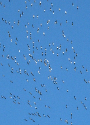
It is interesting to observe the birds coping with this. I was building a five-foot-high snow tetrahedron up in the Meadow the other day, and heard that strange warbling chorus of the flocking Sandhill Crane*. Clouds swirled over most all the sky, with tiny patches of deep blue here and there. Suddenly the noisy cranes came into view, between tall pines, as I saw them, but a few hundred feet above, actually; they formed ragged V's and I estimated the flock at two hundred birds.

The strange thing was, they were heading northeast, as though crossing the Sierra into Nevada; which is likely enough, I am no expert on cranes, but I have seen these tall birds hunt, in their hopping fashion, in the marshes around Fly Geyser Hot Springs, up in the Black Rock Desert.

To fly northeast on this day! With violent snow showers assaulting the crest! What brave and noble birds! Where is the Plutarch, to record their extraordinary lives!

Then, this morning, under a sullen blanket of fog spewing rain and sleet and rain and sleet, a sudden heavy shower drove some perky-crested Stellar Jays into the shelter of a Canyon Live Oak, a gnarled mass of twisted branches and dense evergreen foliage, clinging to a cliff; several jays made the same abrupt move, into the live oak, and while the sleet pounded down and bounced off the soggy snow, the jays moved stealthily lower into the volume of the foliage. More and more and more leaves acted as tiny shingles above them, and they could pick and choose the dry zones.

In June, when the young of the Stellar Jay emerge from the nest in adult plumage, they exhibit a behavior I have seen in other bird species, and which is likely some deeply-rooted and primeval mechanism. The juveniles will wait, on some pine branch, say, for their parents to bring them food, tasty morsels of many kinds, I think; and as the parents wing into view, the juveniles slightly spread their wings, and beat them rapidly, and squawk excitedly, saying "Here I am—feed me! feed me! feed me!"

I took some corn chip crumbs out to the cement steps, and scattered them over steps and snow alike, and waited inside. Soon a crowd of jays discovered the treasure. I was intrigued to see one jay holding its wings a little akimbo and beating them rapidly. It was the juvenile "feed me" behavior, yet this bird was an adult, a near-yearling at the least.

There did not seem to be much aggression or competition between the half-dozen jays on the steps. But crumbs were plenty.

I saw that the jays preferred the steps to the snow; I suspect they fear exposing their deep blue bodies against white snow to the sharp eyes of some hawk. The darker background of wet cement would guard them from the hawk's keen eyes.


Paleovalleys and Ignimbrites
[North Fork Trails blogpost, March 8, 2006:
http://northforktrails.blogspot.com/2006/03/paleovalleys-and-ignimbrites.html ]
English is an Indo-European language, as are two “dead” languages, Latin, and the still older Sanskrit. From the Sanskrit “Agni,” (god of the hearth, and mediator between gods and men) we move to the Latin “ignis,” fire, from which we get our English “ignite,” and also that vastly rarer word, “ignimbrite,” meaning “fire rock” or welded tuff; and “tuff” (not tufa) is volcanic ash.

Rhyolitic volcanoes tend to have explosive eruptions in which a “glowing avalanche” of incandescently hot lava particles will spread out, perhaps flowing down a valley, and just so soon as that glowing avalanche stops, it freezes into solid rock. It is a cataclysmic event and will kill everything in its path.

There are basaltic tuffs, andesitic tuffs, and rhyolitic tuffs. In this part of the Sierra we have an abundance of rhyolite tuffs. Some are welded tuffs, some were air-borne ashfalls which did not weld, and were either immediately or subsequently remobilized by water; for a long time we have called all these rhyolite tuffs, the Valley Springs Formation, yet they are clearly composed of several to many different tuffs, spanning millions of years of time, beginning, say, in the Oligocene of ~30 m.y.b.p. (million years before the present) to the Miocene of ~20 m.y.b.p.

Hence we ought to split the Valley Springs into smaller, individual formations.

Strangely, although so close to major population centers and hence, to universities with geology departments, the Valley Springs Formation has not been exhaustively studied. Only now are some of its secrets being unlocked; similarly, only now is the much more recent (<3 m.y.b.p.) glacial era coming into focus; and there is so much remaining to discover here in the Sierra, on so many fronts.

It is a good time, a great time, to be a geologist in the Sierra Nevada. When one visits the web pages of these various professors and graduate students, and, sometimes, undergraduates, one sees they must live Indiana-Jones-like lives of high adventure, in lands of danger and mystery; for, hark, there they go, to the wilds of the Tien Shan mountains in northern Tibet, and they study some violent fault zone of critical import, in forming a model of Himalayan geology.

And then, in the summer, say, they come back to the Sierra and examine ignimbrites, in a certain paleovalley which seems to have run from near today's Honey Lake in the north, down past Soda Springs at I-80, and then crossing the upper North Fork to French Meadows reservoir on the Middle North American; thence joining the main Tertiary South Yuba near Michigan Bluff, and on past Yankee Jims and Iowa Hill to Gold Run and points north.

Since it is a paleovalley, predating our modern canyons, its originally continuous course has been broken not only by erosion (i.e., cut by our modern canyons), but by block-faulting: this paleovalley crosses the main Sierra Nevada fault, at a very shallow angle, just north of Castle Peak. To the west of this fault is the upthrown block: the Sierra. To the east is the downthrown block: Lake Tahoe, the Martis Valley, Highway 89 north of Truckee.

The main Sierra Nevada fault is really a stepped series of roughly parallel faults, all along the east side of the Sierra Crest, from south of Mount Whitney, north to about Yuba Pass. A little farther north, and we leave the Sierra for the southernmost of the Cascades volcanoes, Mt. Lassen. The thickness and extent of the “young volcanics” (of which these rhyolite tuffs form a part) is much greater here, in the northernmost part of the Sierra, and the volcanics often obscure bedrock and faults alike.

Back to the paleovalley. Around 1900, the USGS's Waldemar Lindgren mapped it as originating near Castle Peak; the idea that it may originate near Honey Lake (at Diamond Peak) results from field work by accomplished geologists and petrologists including student Dylan Rood, professor Cathy Busby of UC Santa Barbara, and David Wagner, a State geologist.

I should say that the idea of our Sierran paleovalleys having their headwaters east of the Sierra crest, in modern Nevada, is not new at all, but has yet to be widely demonstrated. The ~16 m.y.b.p. Lovejoy Basalt of the Northern Sierra, also presents the case of a paleovalley extending east into Nevada.

But in this particular “Diamond Peak” paleovalley, a little west of Honey Lake, they find five distinct ignimbrites, composed of nine cooling units. They correlate units 1, 4, and 7 of the Soda Springs paleovalley, with units 3, 4, and 5 of the Diamond Peak paleovalley.

Around ten years ago, I accompanied paleontologist Howard Schorn and geologist Dave Lawler to a site in the Soda Springs paleovalley, where we recovered some finely-detailed plant fossils from the river gravels beneath the ignimbrites. But the stratigraphic relations were not exposed there, in fact, we were finding the fossils in an anonymous creeklet threading through glacial till.

These ignimbrites are broadly similar to the famous Bishop Tuff of the Owens Valley, 35 cubic miles of welded rhyolite ash which erupted in an instant from the Long Valley caldera a mere 750,000 years ago; so our local tuffs are much older.

Rood et. al. remark that the lower three ignimbrites were confined to the paleovalley, while the fourth overflowed here and there, and the fifth and uppermost ignimbrite, the youngest, spread more widely still, scarcely at all confined by the paleovalley.

The sources of these tuff-beds seem all to be to the east, in Nevada, some rhyolitic calderas having been found in the central part of the state, of the same ages. At that time the Sierra had not been uplifted, and the source region of the calderas was higher in elevation than here, so the glowing-hot fiery avalanches of rhyolite ash traveled long distances, down the paleovalleys.

One of these five ignimbrites of the nine discrete cooling units is David S. Harwood's “pink welded tuff,” dated to 22 m.y.b.p., as discussed in his USGS geological map of the Duncan Peak and Cisco Grove quadrangles. Generally speaking, rhyolite tuffs are light in color, white, cream, buff, tan, grey. This “pink welded tuff” is well-exposed in the vicinity of Palisade Lake, just west of Soda Springs. The westward continuation of Pahatsi Road, in the Serene Lakes subdivision, to Cascade Lakes, crosses the glaciated surface of this ignimbrite for about a half-mile, atop the South Yuba-North Fork American divide. Huge granite erratics are scattered everywhere, and one can drive right by thinking that the flat glaciated “bedrock” is granite, too; but it is a welded tuff, and it is Superjacent Series all the way, not Subjacent Series, like our granites.

At Palisade Lake this ignimbrite is seen, in cross-section, to have a massive vertical columnar structure; hence, I think, the name of the lake and of Palisade Creek, a south-flowing tributary of the North Fork. Which of Rood et. al.'s nine cooling units Harwood's “pink welded tuff” is, I cannot say.

These ignimbrites, these welded tuffs, are commonest near the Sierra crest, and are not found much if at all as far west as Dutch Flat. Here, the equivalent tuff-beds are sometimes well-consolidated and seem rather welded, but more typically, they are clearly water-deposited, and have sometimes weathered into a grey clay. The Dutch Flat store is built from the possibly-welded rhyolite tuff of this area. No, here in the lower elevations, so far away from the source calderas, our tuffs tend to be weak, so weak as to almost never be exposed at the surface, as outcrops; near the head of the Green Valley Trail is one small exposure, and there are others around Lake Alta, and west, at Chalk Bluffs.

Well, at any rate, I am delighted that new work is being done on our “young volcanics.” This same team, Rood et. al., look to be involved in studying the next-younger members of the Superjacent Series, the andesitic lahars and all their variants, down in the Carson Pass area. With modern radiometric dating tools, we should gain a much more sophisticated portrait of our late-Tertiary volcanism.


Snow, Storms, and Lions
[North Fork Trails blogpost, March 8, 2007:
http://northforktrails.blogspot.com/2007/10/snow-storms-and-lions.html]
At last the snow is melting away, the recalcitrant snow, the stubborn snow, the snow which defies day after day of temperatures in the sixties. At 4000' elevation it is all microclimate. Where I live, a few dozen yards separate “The Meadow,” where it has been freezing every night, from “The Cabins,” where it has not dropped below forty degrees for a week or more. The Meadow slopes gently south, but too gently. The Cabins are on a steep south-facing slope.

Hence The Meadow has an unbroken expanse of snow, and in the flat places the snow is still nearly two feet deep.

Yet The Cabins have only small masses of snow here and there, mainly where conifers shed big heaps—these are ring-shaped masses; or on trails, where the flatness of the trail-bed itself is not south-facing, and the snow has been slower to melt; these are linear masses.

They say that Eskimos have fifty different words for snow. We use a couple here in the Sierra, rather imprecisely. One will hear people talk of “powder snow,” or its near-opposite, Sierra Cement. These terms lack precision. To confuse the matter further, the ski areas, knowing people prefer powder to ice, will report a “base” depth of, say, ten feet, and describe conditions on the ski runs as “packed powder,” when a more truthful description would be “groomed ice.”

Anything west of the Sierra Crest can be counted a maritime climate, versus the continental climates found east of the crest. The influence of the ocean moderates the climate west of the crest, keeping it much warmer. Hence Blue Canyon, at 5200', very very rarely ever has temperatures below zero, while Bridgeport, at the same elevation but east of the crest, along Highway 395, drops below zero degrees many times each fall, winter, and spring.

In fact, Bridgeport once held the low temperature record for the entire United States, flat-out 56 degrees below zero. It lies in a large flat valley encircled by mountains. Cold air settles in and intensifies.

At any rate, genuine powder snow, of the sort they have in the Rockies or in Utah, is a rarity in the Sierra. We do get it from time to time, but usually when the weather people on TV are waxing poetic about powder in the Sierra, it's really the good old Sierra Cement, which is a warm and heavy and sticky snow, somewhat light and fluffy in the first hours after it falls, but let one sunny day go by and, watch out.

The recent sequence of storms laid down the wettest and heaviest of Sierra Cement here at 4000', and as so often happens, periods of real snow were punctuated by periods of what I call “snain,” a mixture of snow and rain, which often looks like snow from the comfort of one's living room, but go outside and you will be getting wet.

This “snain” settles and compacts and wets whatever real snow it falls upon. Freezing temperatures, such as are likely between storms, transform this dense snowpack into a nearly monolithic mass of ice. Let a mixture of snow and snain fall for a week running and one has three feet or so of a material which will stoutly resist melting.

Yesterday afternoon I thought it a good time to burn a pile of brush I had cleared from what we call the High Trail, on a steep slope west of here. The slope is too steep for safe burning in dry conditions. But I expected to find it still partially covered in snow, and it was, so I set to work, and safely burnt the slash, a struggle to be sure, since this brush was itself still partly buried in snow, and I had some wrestling matches merely to pull it free. As the sun lowered in the west, patches of bright sunlight broke through the clouds. I walked back to The Cabins in a meditative mood, my feet sinking deeply into the linear masses of trail-snow. I paused often to admire the scene, and visited some low cliffs which offer a view east. There was sun dappling the North Fork canyon all the way up to Snow Mountain and the Royal Gorge, where the snow-clad cliffs of Wabena Point were almost hidden within light snow showers. The crest itself was lost in clouds.

Now, night-before-last my son Greg reported hearing the sounds of an animal crashing through brush immediately below the Big Cabin, and whatever it was make cat-like "yowling" sounds.

“A bobcat,” I responded at once. For bobcats are common here, and they often vocalize. Once the oak leaves which litter the forest floor dry out, even a small animal sounds like a big animal. A squirrel can sound like a bear.

But then, last night, I myself heard an animal crashing through the brush below the Big Cabin, and no yowling, but one explosive almost bird-like squawk, pitched high. The brush-crashing continued to the west and then quieted.

I related this to Greg and offered a guess, that perhaps a deer made the squawk, as they do make a wide variety of sounds, which few people ever hear. Deer bellow plaintively, for instance, and deer also bark, a dry, coughing, huffing bark. They also bleat like goats, but more softly.

This morning, at dawn, I decided to walk out west and higher to visit my burn pile. As I reached one of the linear masses of trail snow, I saw mountain lion prints from last night. They had not been there yesterday. They could only be from the animal which had been crashing around below the Big Cabin.

Track of Mountain Lion (Puma concolor)
Mountain lion prints resemble those of a large dog, but there are no claw marks. These were well-preserved, as they had been made about eight p.m., and the coolness of the night had not melted much snow.

It was interesting to note that the lion had stepped in my own tracks of the afternoon whenever it could, and if opportunity offered to get out of the snow altogether, it took it. I photographed a few of the tracks; they are probably the most exact and complete lion tracks I have ever seen. For those who have Storer and Usinger's “Sierra Nevada Natural History,” (U.C. Press, Berkeley), the tracks were exactly as depicted in the Mammals section, Figure 22, on page 328 of the 1973 printing.

So, I warned my family about the lion. Often they arrive home from work and school after dark, and nowadays, with the snow and all, it is a walk of a few hundred yards from car to cabin.

I tracked the lion quite a ways west on the Old Trail. Its tracks were only visible in the linear snow masses, and even then, where it had stepped exactly into one of my own boot-tracks, they were unrecognizable. Only in those few places where it was more or less forced to step in the unbroken snow, had it done so. Two nights in a row it has come near the cabins.

It is fun to observe animal tracks, and I have seen many fox trails, many squirrel paths, and even the tracks of ground-loving quail, written in the snow lately.


*More on Sandhill Cranes
(Grus canadensis)
 
Video and audio of  flying, and landing on water ~

http://en.wikipedia.org/wiki/File:Grus_canadensis_-Bosque_del_Apache_National_Wildlife_Refuge,_New_Mexico,_USA-8.ogv

Some interesting facts from the Nature Conservancy page on Sandhill Cranes:
http://www.nature.org/animals/birds/animals/sandhill.html
“Some evidence points to cranes as the oldest known bird species surviving on Earth. A crane fossil found in Nebraska, estimated to be about 10 million years old, is identical in structure to the modern sandhill crane.

Though cranes and herons share some similarities in appearance, they are actually only distantly related. ...  It can be difficult to tell the difference between herons and cranes in flight. One of the easiest ways to distinguish the birds is to remember that herons fly with their necks curved and cranes fly with their necks straight.”


March 4 (1979, 1988, 2004)
White Warnings to the World

3/4/79 ~ a clear sunny morning, birds call out and a few patches of fog cling to the canyon walls. yesterday the sun finally made it through at the end of the day, and there was glorious color in the fogs of giant gap.”

[Russell Towle's journal]
 

3/4/88   Friday morning; just returned from the Knoll, where last night I began burning some raspy old ceanothus, and this morning concluded the episode, taking care of odds and ends. I saw a most wonderful sight from the Knoll, looking down into the meadow, where several deer had been hanging out when I first walked up from the cabin. Among them, two fawns, nearly a year old now; I was burning, tending the fire, when was heard the sound of hoofs earnestly beating the ground (hooves?); in the meadow a fawn gamboled, nay, did more than just gambol, it charged around in circles, using the bounce-gait of high alarm, cutting figure-eights, racing here and there, establishing a sort of race-course for itself, around one of the dogwoods, then back below the large cedar; its sibling was standing near the edge of the Western Grove, and by repeated charges and near-misses the gamboler induced it to join in the fun; it was a most laughable sight, and went on for about five minutes or so. I noticed that, while dashing so emphatically about, in four-footed bounce-gait, it held its tail high and stiff, flashing out white warnings to the world.

I am now cooking the very last of my food, a scant handful of spaghetti; I hope, but must perforce doubt, that a check will be in my box today.”

[Russell Towle's journal]


Trails, Public Access, Legal Issues
[North Fork Trails blogpost, March 4, 2004:
http://northforktrails.blogspot.com/2004/03/trails-public-access-legal-issues.html ]
Quite a number of historic trails have been lost to public use here in Placer County. A variety of causes can be identified. For instance, not a few trails have been casually obliterated during timber harvests. At least as often, a trail has been blocked by a gate and ‘no trespassing’ signs, as, for instance, in the upper North Fork, the Heath Springs Trail has been arrogated to private use by a group or club known as The Cedars. Or, right here in the Gold Run area, the Fords Bar Trail has been closed to the public for about fifteen years. In this case Placer County signed off on a subdivision at the trailhead, and where the Fords Bar access road forked away from Garrett Road, a county road sign now marks it as “Knobcone Road,” an apparent attempt to disguise its true name and history.

Now, one trail connects to another, quite often, and here in Placer County we once had a rich complex of interconnecting trails. Those who used and loved these trails felt a crisis had been reached at least as early as 1953, when a Placer County Board of Supervisors Ordinance was passed which declared all trails depicted on official United States Geological Survey maps of lands in the county, to be public trails. The ordinance provided misdemeanor-type penalties for closing or obstructing any such trail, and specified sixty particular trails to be public trails, without, however, limiting the definition of a public trail to those particular sixty.

The Fords Bar Trail was one of the sixty, but the upper Heath Springs trail, leading down the river from The Cedars was not. Parenthetically, the continuation of the Heath Springs Trail west into Palisade Creek was one of the sixty trails specified. I suspect that Cedars members strenuously objected to the inclusion of the Heath Springs Trail in the list, and managed to get it removed; but I do not know that.

Public access to historic trails is quite a difficult issue. It raises controversy. It is nothing at all new. For instance, in 1850, I believe, the nascent legislature of California provided that all “emigrant trails”—such as the Donner Trail, or one of its branches, the Old Emigrant Road leading through Dutch Flat—were public roads. We would probably be safe in imagining that problems had arisen even then—an emigrant road was gated closed, or someone decided to charge a toll for its use. So the legislature acted on behalf of the public.

Somewhat similarly, Congress enacted Revised Statute 2477, as I recall, in the 1860s, and perhaps “revised” it in 1872. This provided in the most general terms for public access across public lands. It was intended in part to provide for continued public use of roads and trails across lands which had been Federal lands but which passed into private hands, either through railroad land grants, or patented mining claims, or homesteading. Hence to this day when the public tries to assert its right to use some old trail, R.S. 2477 may at times come into play.

More recently, as California’s population grew and spread ever more widely across what had been open space, both historic trails and rough ad hoc paths to our beaches were closed to the public, up and down our coast. It has long been the sense of our lawmakers that the beaches themselves are public lands; usually the boundary is taken to be the “mean high tide line,” which can be difficult to define. But as more and more of these beach trails were gated closed, or houses were built right over the trails, the issue of public access across private lands to public lands (the beaches) heated up. The public began to go to court.

One case in particular, Gion vs. the City of Santa Cruz, 1970 (as I recall), led to a better definition of old common-law concepts: prescriptive rights, implied dedication, and adverse use. That is—and I suspect the legal history of the notion might be traced back to the Romans, for that matter—the public, or even an individual, can be considered to have acquired a right to use such-and-such road or trail across private property, by using that trail “adversely.” It is not required that the trail first be used, say, when the property in question was public land; the use may well have begun when the property was private—but the essential ideas, as I understand them, are that the use was considerable, and that it occurred for a period of at least five years, and that the owner knew about the use and did nothing to stop it. There results an “implied dedication” of that road or trail to the public.

Suppose the owner of the property claims that he did not know of the use, and therefore, the use was not adverse. In such a case the courts may appeal to old (or new) maps. If the trail is depicted on, say, the official USGS map of the area, the courts tend to rule, as I understand it, anyway, that the owner ought to have known that there was adverse use.

Sometimes one hears that “adverse use” must be even more extreme to really establish its legal standing, i.e., if the owner puts a gate up, that gate is torn down.

At any rate, one can imagine a lot of problematic gray areas around this whole concept of prescriptive rights and adverse use; and Gion vs. the City of Santa Cruz helped clarify those problems.

Around the same time as this famous case, the California Coastal Commission was formed, in an effort to keep our coastline from being literally lined with houses. Part of the work of this Commission has been to protect public access to the beaches, across private lands. At any one time the Commission is studying various trails to see whether they fall within the scope of prescriptive rights and implied dedication, as set forth in Gion vs. the City of Santa Cruz.

The legal concept that our beaches are inalienable public lands is echoed in the idea that “navigable rivers” are also inalienably public. Some number of cases have gone to trial involving public access to a river, or perhaps more specifically, public use of a river’s banks as well as its waters, cases which have appealed to this “navigable river” concept.

Here in Placer County, there was apparently quite an outcry against the 1953 BOS ordinance. I have not researched this supposed outcry, made, presumably, by property owners. In 1954 the BOS repealed the 1953 ordinance and enacted a new ordinance which specifies no one trail, mentions no maps, and provides only that all public trails and roads shall remain open to the public. In effect, the burden of proof was placed on the public itself. The gates remained closed, the no trespassing signs remained in place.

One might well think that the public agencies (Tahoe National Forest, and the Bureau of Land Management) which manage public lands in Placer County would aggressively defend the public’s rights to use the historic trail complex. At one time, TNF did work to protect public access. That was several decades ago. Times changed, and today TNF staff do not even realize that their predecessors placed trail signs, maintained trails, and even interceded when some private property owner gated a road or trail closed. Recent decades have seen, in stark contrast, TNF signing off on timber harvests which obliterate the historic trails, and sitting on their hands waiting for The Public to defend its rights.

Locally, in the early 1980s a historic road to the Bear River near Dutch Flat was gated closed. At the river is a lovely pool for swimming. The place is called Smarts Crossing; there once was a bridge across the river there, and the road climbed to Liberty Hill, on the north canyon rim. With the pro bono help of several attorneys, most notably Ed Stadum, local residents filed suit to establish the public’s right to use the road to Smarts Crossing. They won the case in Superior Court, Hon. James Garbolino presiding. A combination of old maps and testimony by people who had used the road over the course of many years decided the issue.

Still more recently, a canal in the Nevada City area with a nice berm, long used by hikers, was gated closed. An ad hoc group called Friends of the Trails formed and went to court in 1997 to defend the public’s rights to use that canal berm; and they won.

Consider the (upper, more easterly) Heath Springs Trail, which leads down the North Fork from The Cedars, to Heath Springs, and then continues beyond into the basin of Palisade Creek (we could call these two segments of one trail the “eastern” and “western” Heath Springs Trail). There it (the Western HST) joins the Palisade Creek Trail and one may continue west on the Long Valley Trail (or one could; there have been recent timber harvests in Long Valley, and this old trail may have been obliterated). These trails are depicted on current USGS 7.5 minute topographic maps, specifically, the Royal Gorge, Soda Springs, and Norden quadrangles. It is very likely that they are shown on many older USGS maps, and the Heath Springs Trail in particular is depicted on TNF maps dating from 1928, 1939, and 1962 (and likely other editions of TNF maps as well).

There are a number of old magazine and newspaper articles and even one diary which describe public use of trails in this area, without ever mentioning the Eastern or Western Heath Springs Trail by name. I guess, but do not know, that use of these trails continued unopposed by the Cedars down to at least the 1930s, if not later. I suppose we would have some trouble finding anyone alive able to testify to the public’s use of the Eastern HST in the 1930s. It is not impossible, just unlikely. There may be TNF records pertaining to this trail which would serve to demonstrate that it indeed was, as one would surely think to look at the maps, part of the TNF trail system.

The 1997 Friends of the Trails case went to the California Court of Appeal, Third Apellate District, which filed its opinion upholding the public’s right to hike on the canal berm on February 28, 2000. Within this document the Court discusses Gion vs. the City of Santa Cruz in detail, and the concepts of adverse use, implied dedication, and prescriptive rights. One footnote, perhaps bearing upon the Heath Springs Trail, is as follows:
We caution that the court’s comment concerning an occasional hiker on
isolated property should not be construed as suggesting that any instance of
recurrent “public” passage over private property could qualify as adverse
use for purposes of implied dedication. The use must be substantial,
diverse, and sufficient, considering all the circumstances, to convey to the
owner notice that the public is using the passage as if it had a right so to
do. Thus, e.g., a long history of continued passage by a diverse group of
occasional hikers across a well defined privately owned trail segment
leading to a network of trails, say on a pubic wilderness area, might
suffice.
The significant thing here is use of a privately-owned trail segment “leading to a network of trails.” That is the case with the Eastern HST. It is just one of the facts which The Cedars must regret, for it is only natural for sane and sensible judges to give more recognition of public rights, when a trail, on private property, actually goes through to public lands and connects to other trails which are unequivocally public. Thus The Cedars’ Ted Beedy was quite insistent, in correspondence with me, that the Heath Springs Trail did not go through to Palisade Creek until the late 1970s. However, the old maps prove him wrong.

The Placer County trail complex is in tatters, partly ruined by logging and the road-building which enabled logging, partly ruined by gates and “no trespassing” signs. Were it not for Harry Mayo’s Rawhide Mine and The Cedars, one could walk from Alta to Squaw Valley, paralleling the North Fork of the American. In 1870, I.T. Coffin of Dutch Flat hiked from Old Soda Springs to Blue Canyon along much of this route, and almost certainly used the Eastern and Western Heath Springs trails—for there is pretty much no alternative. His description of that hike is threadbare and without detail. He records camping in Big Granite Creek canyon, then known simply as Granite Canyon, the first night out. The Long Valley Trail leads over a pass from Palisade Creek into the basin of Big Granite Creek, just north of Snow Mountain. And the Heath Springs Trail is the most direct way to get from Old Soda Springs to the Long Valley Trail. I am certain I.T. Coffin used this route.

Such, then, is a little background about our historic trails, and the problems we confront in using them, and the legal remedies which exist.

In some cases I believe that land acquisition is the best answer. Take the Rawhide Mine, just east of Alta, at the confluence of Blue Canyon and the North Fork of the North Fork, where all kinds of “no trespassing” signs and gates block the public from using the historic trail which leads through the private property to other trails on TNF lands. The crucial 80 acres which has pinched off our access is for sale, right now. Obviously (I think), TNF should buy it. But money is a problem. TNF did not even get the FY2004 Land & Water Conservation Act funds for its long-planned acquisitions of old railroads lands (now owned by Sierra Pacific Industries, a lumber company) farther up the North Fork.

What will happen? Probably someone will buy the Mayo/Rawhide property and a whole new crop of “no trespassing” signs will be nailed up beside the old signs.

In other cases, like The Cedars, land acquisition would not be the answer. To protect our right to hike the Heath Springs Trail we would have to go to court. I believe we would prevail. And I can imagine some compromises which might conceivably be made, which would on the one hand allow public use of the trail, and on the other hand, work to protect The Cedars’ privacy.

These are difficult issues. If we care about the future of the North Fork, we’ve got our work more than cut out for us.


March 1 (1979, 1986, 1988, 2001)
Exquisite! Roiling and Glowing, the Tensions of Spring

3/1/79 ~ still snowing, after dumping about two feet last night, but the sky is glowing through the snow and it will be clearing up. it is exquisite, truly exquisite. oh god! i even see a bit of blue sky! i hear george barnes playing green dolphin street. django reinhardt playing beyond the sea. i woke up grumpy but i'm happy now. oh, the roiling glowing clouds above me ~ if i could fly and stay warm, i'd shoot up for a peek.”

[Russell Towle's journal]


March 1, 1986  Partly cloudy today, but warm, with a certain tension in the air, a tension which heralds spring. [...]

I was just outside, gathering oak twigs and branchlets for kindling; atop the hand-hewn redwood barn timber from Año Nuevo some branchlets were laid to dry. I went to retrieve them; two Western Fence Lizards were — what? — making love in their shelter. I knelt to watch them; they'd moved apart, within inches of my rapt gaze; I studied their intricately imbricated scales, which reminded me of polar zonohedra, I studied their eyes, so like my own, and whispered appreciation: they watched me closely as well. I compared the lengths of their toes and fingers, terminating in delicate claws; finally I seemed to see the eyes of what I took to be the female, dull, narrow; I thought, gosh, if I don't get out of the way, she many have no eggs this spring!! So I left.”

[Russell Towle's journal]


About the Western Fence Lizard:
“It is thought that the presence of western fence lizards diminishes the danger of transmission of Lyme disease by ticks. The incidence of Lyme disease is lower in areas where the lizards occur, and it has been found that when ticks carrying Lyme disease feed on these lizards (which they commonly do, especially around their ears), the bacteria that cause the disease are killed.”

http://en.wikipedia.org/wiki/Western_fence_lizard

March the First, 1988  afternoon; after several days of storm, the temperatures have dropped, and now hail rather than rain showers down; a sign that the storm has in the main moved past and to the east, and, since cyclonic, since in the northern hemisphere cyclonic storms rotate counter-clockwise (as seen from above), it then happens that, moving from west to east as is their wont, either north or south of the equator, they drag cold air in behind them. The same would be true south of the equator, where storms would begin with north winds, finish with southerlies; cold southerlies stemming from the pole and hastening equatorwards... the names given to the winds of the various quarters and octants by the Greeks and Romans reflect the characteristic weather-types associated with those winds throughout temperate latitudes; that is South Wind is cloud-bearing, sea-roiling; North-East Wind, hot and dry (sometimes cold and dry)...”

[Russell Towle's journal]


Date: Thu, 1 Mar 2001 15:50:57 -0800
To: North_Fork_Trails Email Group
From: Russell Towle
Subject: Canyon Creek


Hi all,

I have put a few pictures taken along the Canyon Creek trail on a web page at:

http://northforktrails.com/RussellTowle/NorthFork/Trails/North_Fork_Trails.html
Cheers,

Russell Towle